
Isolation 0.29 mi (0.47 km) Prominence 24 m | Elevation 2,147 m | |
 | ||
Topo map USGS 7.5' topographic mapMorrison, Colorado Easiest route walk from Lookout Mountain Road (Lariat Loop Road) Similar South Table Mountain, Lookout Mountain, North Table Mountain, Front Range, Eldorado Mountain | ||
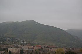
Mount Zion is a foothill on the eastern flank of the Front Range of the Rocky Mountains of North America. The 7,062-foot (2,152 m) peak is located in Windy Saddle Park,1.7 miles (2.7 km) west (bearing 273°) of downtown Golden in Jefferson County, Colorado, United States.
Contents
Map of Mt Zion, Colorado 80401, USA
TraditionEdit
One notable feature of Mount Zion is a white "M", maintained by the Colorado School of Mines. All freshmen attending the school climb the mountain and each add a rock on the "M" which they can take with them when they graduate. This is a tradition that has been going on since 1908 when the M was first created. The "M" has been permanently lighted since 1932.
References
Mount Zion (Colorado) Wikipedia(Text) CC BY-SA