
Topo map USGS Blue Diamond Elevation 2,155 m Mountain range Spring Mountains | Easiest route Scramble Prominence 204 m Parent range Spring Mountains | |
 | ||
Location Clark County, Nevada, U.S. Similar Harris Mountain, McFarland Peak, Bridge Mountain, Griffith Peak, Mummy Mountain | ||
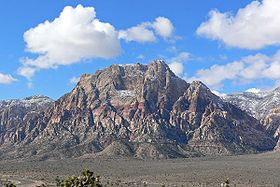
Mount Wilson is a mountain located in the Spring Mountain range of southern Nevada. It is located on land managed by the United States Bureau of Land Management as the Red Rock Canyon National Conservation Area, part of the Rainbow Mountain Wilderness Area. It is the highest peak in the Red Rock Canyon National Conservation Area.
Contents
Map of Mt Wilson, Nevada 89161, USA
Mount Wilson is 17 miles (27 km) west of downtown Las Vegas in Clark County, Nevada.
Hiking RouteEdit
Mount Wilson's sandstone cliffs are accessible to hikers starting at the First Creek trailhead and proceeding west into First Creek Canyon. From there, at least two distinct and strenuous third-class routes lead to the summit.
References
Mount Wilson (Nevada) Wikipedia(Text) CC BY-SA