
Location Victoria, Australia Parent range Grampians National Park | Elevation 1,167 m | |
 | ||
Topo map Geoscience Australia Mount William First ascent Thomas Mitchell (European explorer) Similar Mount Arapiles, Mount Napier, Mount Dom Dom, Mount Buninyong, Mount Donna Buang | ||
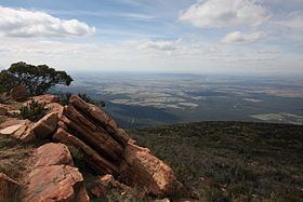
Mount William (also Mount Duwil) is a mountain of the Grampians Mountain Range, located within the Grampians National Park, in the Australian state of Victoria. The mountain is situated approximately 250 kilometres (160 mi) west-north-west of Melbourne on the eastern edge of the national park, approximately 22 kilometres (14 mi) drive from Halls Gap.
Contents
Map of Mount William (Mount Duwil), Pomonal VIC 3381, Australia
Features and location
Mount William is the highest point within the Grampians National Park. Sir Thomas Mitchell reached the summit with a group of explorers in 1836. The first settler in the area was Horatio Wills, who established a sheep run at Mount William in 1840, and named nearby Mount Ararat, after which the town is named. His son, cricketer and Australian rules football pioneer Tom Wills, grew up as a lone white child among the Djab wurrung Aboriginal tribes of Mount William.
Three transmission towers are located at the summit of Mount William including an amateur radio repeater. A sealed service road continues to the summit, but is not accessible by vehicle to the general public.
Visitors to the mountain can drive to a carpark located approximately 920 metres (3,020 ft) up the mountain, before proceeding on foot for 1.8 kilometres (1.1 mi) to the summit. It will take a person of moderate fitness approximately 45 mins to walk. No permit is required to climb the mountain.