
Elevation 781 m Province Maluku | Last eruption 1968 | |
 | ||
Similar Manuk, Banda Api, Mount Wurlali, Iyang‑Argapura, Ilimuda | ||
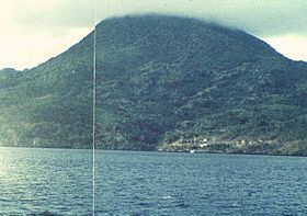
Nila volcano forms completely an isolated 5 × 6 km wide of island with the same name in the Barat Daya Islands of the Banda Sea, Indonesia. The volcano comprises a low caldera with its rims breach into the sea surface on the south and the east side. The dominantly andesitic volcano contains a young forested cone at the elevation of 781 m height.
Map of Mount Nila, Ilih, Damer, Maluku Barat Daya Regency, Maluku, Indonesia
Mount Nila is a stratovolcano, and caused the abandonment of a Rumadai village when it erupted in 1968.
References
Mount Nila Wikipedia(Text) CC BY-SA