
Isolation 2.39 mi (3.85 km) Prominence 486 m | Elevation 3,475 m | |
 | ||
Topo map USGS 7.5' topographic mapPaonia, Colorado Mountain range San Juan Mountains, West Elk Mountains Similar Needle Rock Natural A, Marcellina Mountain, Flat Top Mountain, East Beckwith Mountain, Mount Owen | ||
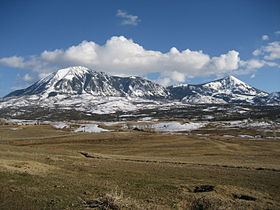
Mount Lamborn is a mountain summit in the West Elk Mountains range of the Rocky Mountains of North America. The 11,402-foot (3,475 m) peak is located in Gunnison National Forest, 5.9 miles (9.5 km) southeast by south (bearing 141°) of the Town of Paonia in Delta County, Colorado, United States. The summit of Mount Lamborn is the highest point in Delta County. Together with nearby Landsend Peak to the southwest, it lies at the western edge of the West Elks, rising dramatically nearly 6,000 ft (1,800 m) above the valley of the North Fork Gunnison River to the west.
Map of Mt Lamborn, Colorado 81428, USA
References
Mount Lamborn Wikipedia(Text) CC BY-SA