
Elevation 1,339 m | Easiest route Hiking | |
 | ||
Pronunciation Japanese: [kanmuri-yama] Similar Mount Jakuchi, Mt Jippo, Mount Osorakan, Mt Shiraki, Mt Kogoro | ||
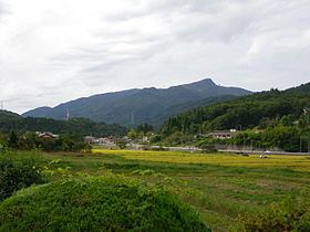
Mount Kanmuri (冠山, Kanmuri-yama), also known as Mount Yoshiwa Kanmuri (吉和冠山, Yoshiwa Kanmuri-yama), is a mountain located in the Yoshiwa District of Hatsukaichi, Hiroshima Prefecture, Japan. "Kanmuri" is a common name for mountains in Japan; Hiroshima Prefecture has six mountains by this name alone, hence the modifier "Yoshiwa".
Contents
- Map of Kammuri yama Yoshiwa Hatsukaichi Hiroshima Prefecture 738 0301 Japan
- Description
- Recreation
- Transportation
- References
Map of Kammuri-yama, Yoshiwa, Hatsukaichi, Hiroshima Prefecture 738-0301, Japan
Description
Mount Yoshiwa Kanmuri has an elevation of 1,339 m (4,393 ft). The mountain is at the far west of the Chūgoku Mountains, and is part of Nishi-Chugoku Sanchi Quasi-National Park. The plateaus of the southern base of Mount Yoshiwa Kanmuri features large stands of renge tsutsuji rhododendron, and the area is designated a natural monument by the Prefecture of Hiroshima.
Recreation
Mominoki Prefectural Forest (もみのき森林公園, Mominoki Shinrin Kōen) has facilities for camping and hiking, and is located in the fir forests at the eastern foot of the mountain.
Transportation
The Chugoku Expressway, also known as National Route 468, follows the southern base of Mount Yoshiwa Kanmuri.