
Isolation 6.57 km (4.08 mi) Elevation 1,509 m | Mountain type Dolomite Prominence 580 m | |
 | ||
Similar The Acropolis, Mount Pelion East, Mount Gould, Mount Pelion West, Castle Crag | ||
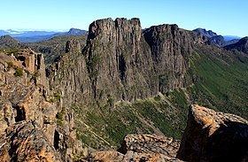
Mount Geryon is a mountain in the Central Highlands region of the Australian state of Tasmania. The mountain is part of the Du Cane Range and is situated within the Cradle Mountain-Lake St Clair National Park.
Map of Mount Geryon, Lake St Clair TAS 7140, Australia
With two peaks, Mount Geryon North has an elevation of 1,516 metres (4,974 feet) above sea level and is the twelfth-highest mountain in Tasmania. Mount Geryon South, with an elevation of 1,509 metres (4,951 ft) above sea level, is the state's fifteenth-highest peak.
The mountain is a major feature of the national park, and is a popular venue with bushwalkers and mountain climbers. It has more than 40 ascent routes for climbers, some of which are over 300 metres (980 ft) in height; however, it is the impressive east face at 500 metres (1,600 ft) in height for which Mount Geryon is most popular.
There is a famous nearby tarn which is known as the Pool of Memories.