
Topo map USGS Cold Bay B-1 Volcanic arc/belt Aleutian Arc Elevation 1,436 m | Last eruption Unknown Parent range Aleutian Range | |
 | ||
Mountain range Aleutian Range, Adirondack Mountains Similar Pavlof Sister, Mount Kialagvik, Kookooligit Mountains, Mount Chiginagak, Ugashik‑Peulik | ||
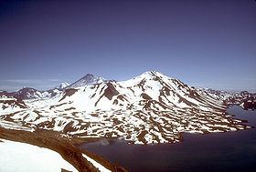
Mount Emmons is a post-caldera stratovolcano within the Emmons Lake caldera on the Alaska Peninsula. It is one of three cones constructed within the 7-by-11-mile (11 km × 18 km) caldera, which also contains an elongated crater lake on its southwest side.
Map of Mt Emmons, Alaska, USA
The most recent of several caldera-forming eruptions at Emmons Lake occurred more than 10,000 years ago. No historical eruptions have occurred at Emmons Lake.
Mount Emmons is a local name published on a USGS map in 1943.
References
Mount Emmons (Alaska) Wikipedia(Text) CC BY-SA