
 | ||
Mount Douglas (SENĆOŦEN: pq̕áls or PKOLS) is a prominent, 225 m (738 ft) hill in Greater Victoria, British Columbia. It is located on the ancestral lands of the Saanich and Songhees people.
Contents
NameEdit
The original name was PKOLS [pq̕áls], used by the aboriginal Saanich and Songhees people. English colonizers changed the name for the second governor of the Colony of Vancouver Island, Sir James Douglas, In 2013, a movement was started to reestablish its original name. The Reclaim PKOLS movement has appealed to the BC Geographical Names Office for a formal name change. There has yet to be an approval of this petition. On May 22nd, 2013, a new "PKOLS" sign was brought to the top of the mountain by a group of WSANEC and Lekwungen chiefs, joined by several hundred supporters . This sign was later removed by the Saanich Parks Board, without consultation, due to their concerns about the anchor bolts interfering with electrical wiring. It was later re-installed at a different location. PKOLS means "White Head" in SENĆOŦEN dialect. This mountain was a culturally significant gathering and meeting place SENĆOŦEN and Lekwungen peoples, a site for ceremonies and sharing important news.
In the mid-nineteenth century, it was called Cedar Hill, and was home to logging operations. Local mills supplied the growing city of Victoria, including the original Hudson's Bay Company fort, transporting lumber south along present day Cedar Hill Road. It was brought under protected status in 1889. Finding no cedars on the hill called "Cedar Hill," Captain Henry Kellett renamed it "Mount Douglas," as recorded in the Fort Victoria Journal by Roderick Finlayson. Although this informal renaming occurred in Douglas' lifetime (it was given the appellation "Mount" in order to honour the governor's status), the name "Mt. Douglas" was not officially adopted until 1910.
The neighbourhoodEdit
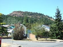
The namesake neighbourhood around the base of Mt. Douglas is a mix of residential neighbourhoods, hobby farms and working farms, roughly bounded by Cedar Hill Road, Cordova Bay Road, the Blenkinsop Valley and Parkside Crescent. The farms of the Blenkinsop Valley (such as Madrona Farm) are protected by the provincial Agricultural Land Reserve.
Mount Douglas Mining CaveEdit
Mount Douglas has many trails. One trail in particular, on its south side (near the north-most point of Glendenning Trail), has an old abandoned mine. The mine has a small entrance, but it opens up inside. The mine is about 50 to 60 feet (15.24 to 18.29 m) in length.