
Elevation 1,200 m | Last eruption 1970 to 1971 | |
 | ||
Similar Mount Iwate, Mt Eboshi, Mt Moriyoshi, Mt Kurikoma, Mount Hayachine | ||
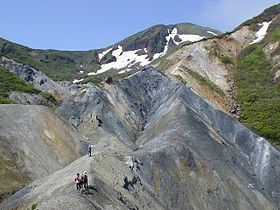
Akita-Komagatake (秋田駒ヶ岳) is an active stratovolcano located 10 km east of Tazawa Lake, near the border between Akita and Iwate prefectures on Honshu Island. The volcano last erupted from 18 September 1970 to 25 January 1971. It is the highest mountain in Akita Prefecture and the second highest in Towada-Hachimantai National Park.
Map of Mt. Komagatake, Tazawako Obonai, Senboku, Akita Prefecture 014-1201, Japan
References
Mount Akita-Komagatake Wikipedia(Text) CC BY-SA