
Isolation 1.86 mi (2.99 km) Elevation 4,249 m | Easiest route Scramble Class 3 Prominence 259 m | |
 | ||
Topo map USGS 7.5' topographic mapHorn Peak, Colorado Similar Columbia Point, Challenger Point, Kit Carson Peak, Humboldt Peak, Crestone Needle | ||
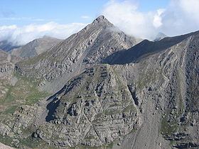
Mount Adams is a high mountain summit of the Crestones in the Sangre de Cristo Range of the Rocky Mountains of North America. The 13,937-foot (4,248 m) thirteener is located in the Sangre de Cristo Wilderness, 5.1 miles (8.2 km) east by north (bearing 81°) of the Town of Crestone, Colorado, United States, on the drainage divide separating San Isabel National Forest and Custer County from Rio Grande National Forest and Saguache County.
Contents
Map of Mt Adams, Colorado 81252, USA
ClimbingEdit
Mount Adams can be climbed using Class 3 routes via the west ridge (Willow Lake), via the southeast face (Horn Creek Trailhead), or via the north west ridge (South Crestone Lake Trailhead).
References
Mount Adams (Colorado) Wikipedia(Text) CC BY-SA