
Area 36.55 km² Population 759 (1999) | Region Occitanie Canton Saint-Girons Time zone CET (UTC+1) Local time Sunday 8:20 PM Arrondissement Saint-Girons | |
 | ||
Weather 12°C, Wind N at 2 km/h, 73% Humidity | ||
Moulis is a commune in the Ariège department in southwestern France.
Contents
Map of 09200 Moulis, France
Geography
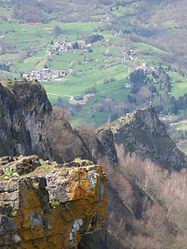
Moulis is situated on the D618 road, which follows the Lez river valley from Castillon-en-Couserans to Saint Girons. Either side of the Lez valley, the land surface of the commune rises steeply to forested mountains, giving a height difference of 1200 m between the lowest point of the commune and the highest.
Population
The inhabitants of Moulis are known as Moulisiens.
Much of the population is grouped in the villages of Moulis, Luzenac, Aubert and Pouech, all of which are in the Lez valley. The rest of the population is dispersed in small hamlets or isolated farms across the commune.
References
Moulis, Ariège Wikipedia(Text) CC BY-SA