
Country Cape Verde Website Official website | Island Fogo Area 89.45 km² | |
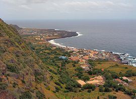 | ||
Mosteiros is a concelho (municipality) of Cape Verde. Situated in the northeastern part of the island of Fogo, it covers 19% of the island area, and is home to 26% of its population. Its capital is the town Mosteiros.
Contents
Map of Mosteiros, Cape Verde
Mosteiros contains one of the few forests in Cape Verde, named Floresta de Monte Velha. The entire terrain are made up of historic lava flows from Mount Fogo which resulted from the last volcanic eruption in 1951. Mosteiros is an agricultural area, its main product is coffee. 96% of the population live with agriculture. The illiteracy rate is very high. 31% of the population are over the age of 15.
Its municipal seal is colored blue with Pico do Fogo and its mountain slope colored grey around it, four coffee beans, the main agricultural production are in the bottom right and on the bottom of the seal reads "Municipality of Mosteiros - Cape Verde" ("Municipio dos Mosteiros - Cabo Verde"), its municipal flag of Mosteiros is colored red with the seal in it.
Subdivisions
The municipality consists of one freguesia (civil parish), Nossa Senhora da Ajuda. The freguesia is subdivided into the following settlements:
History
The municipality Mosteiros was created in 1991, when the older Municipality of Fogo was split in two, the southwestern part becoming the Municipality of São Filipe and the northeastern part becoming the Municipality of Mosteiros.
Politics
The PAICV is the ruling party of the municipality which won 71.9% in the last election and carried 5 seats in the chamber and 10/13 seats in the assembly.
Sports
Its sports clubs of the municipality are Cutelinho FC, Grito Povo and CD Nô Pintcha. It has a football (soccer) stadium named Francisco José Rodrigues.
Twin towns
All of the two twinned municipalities are with those in Portugal: