
Country United States Elevation 606 m Local time Saturday 10:42 PM | Time zone Mountain (MST) (UTC-7) Population 227 (2010) | |
 | ||
Weather 18°C, Wind N at 10 km/h, 35% Humidity | ||
Ranch sorting at western trails ranch morristown arizona
Morristown is a census-designated place in Maricopa County, Arizona, United States. It is about 50 miles (80 km) northwest of Phoenix, at the junction of State Route 74 and U.S. Route 60.
Contents
- Ranch sorting at western trails ranch morristown arizona
- Map of Morristown AZ USA
- Demographics
- References
Map of Morristown, AZ, USA
Morristown is home to the Morristown Elementary School District.
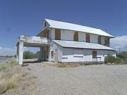
The Morristown Store, formerly the Morristown Hotel, is listed on the National Register of Historical Places.
Much of Morristown is within the municipal planning area of Surprise, and Surprise intends to eventually annex the area. The portion of Morristown south of US 60, however, exists in small area between the planning areas of Surprise, Buckeye and Wickenburg, where neither city has yet expressed a planned interest in expanding. This area is named after Morristown, New Jersey.
Demographics
As of the census of 2010, there were 227 people residing in the CDP. The population density was 508.1 people per square mile. The racial makeup of the CDP was 96.48% White, 0.44% Native American, 0.38% Asian, 0.25% Pacific Islander, 2.20% from other races, and 0.88% from two or more races. 4.85% of the population were Hispanic or Latino of any race.