
Population 594 (2006 census) Local time Sunday 11:17 AM | Postcode(s) 3240 Postal code 3240 | |
 | ||
Weather 28°C, Wind NW at 11 km/h, 34% Humidity | ||
Moriac is a rural town in Victoria, Australia, located approximately 25 kilometres (16 mi) west of Geelong. It forms part of the Surf Coast Shire. At the 2006 census, Moriac had a population of 594.
Map of Moriac VIC 3240, Australia
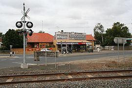
The town was surveyed in the 1920s as a village that had developed around the Moriac railway station on the Port Fairy line. The station had been provided to serve the adjacent community of Mount Moriac. The railway through Moriac opened in 1876, followed by the Wensleydale branch line which junctioned with the main line just past Moriac. The branch line opened in 1890 and closed in 1948. A Post Office had opened on 1 August 1854 as Duneed, and was renamed Mount Moriac in 1864 and Moriac in about 1909.
The town was initially slow to develop, but has grown to house a population of several hundred. Though still heavily rural in nature, the town now largely serves as a satellite village of Geelong, with many residents travelling into the city to work.
The town is home to Moriac Primary School, which has approximately 250 students, a hotel, and a small shop. It also has a kindergarten. The railway station was closed in October 1981.