
 | ||
Moredun is a district of Edinburgh, the capital of Scotland. It is east of Liberton, while Craigour is situated just to its north.
Map of Moredun, Edinburgh, UK
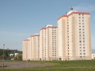
Originally called Gutters and later Goodtrees, the estate was renamed Moredun in 1769. In the sixties six tower blocks were built, whilst all six remain a large project was undertaken to refurbish these tower blocks, to coincide with the building of the Edinburgh Royal Infirmary. Two of these tower blocks, Moncreiffe House and Forteviot House, are within the geographical boundary of Moredun proper, while the other four are in neighbouring Craigour.
Moredun contains two clusters of shops on Moredunvale Road as well as a library and a primary school. It has transport links on a par with other similar areas of the city, with the Lothian Buses service 8 and Edinburgh City Council chartered Lothian and First East Lothian 18 passing through the area, with the 3, 7 and 29 services running nearby.