
Country United States FIPS code 39-51940 Elevation 335 m Local time Saturday 8:39 AM Area code 740 | Time zone Eastern (EST) (UTC-5) GNIS feature ID 1086279 Zip code 43907 Population 420 (2000) | |
 | ||
Weather 2°C, Wind SW at 10 km/h, 98% Humidity Area 71.22 km² (69.67 km² Land / 155 ha Water) | ||
Moorefield Township is one of the fifteen townships of Harrison County, Ohio, United States. The 2000 census recorded 420 people in the township.
Contents
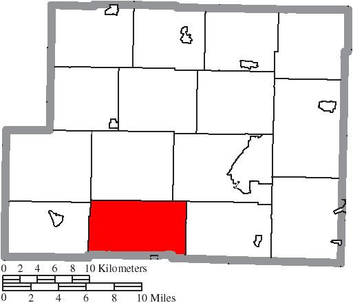
Map of Moorefield Township, OH, USA
Geography
Located in the southern part of the county, it borders the following townships:
No municipalities are located in Moorefield Township, although the unincorporated community of Piedmont lies in the western part of the township.
Name and history
Statewide, the only other Moorefield Township is located in Clark County.
Government
The township is governed by a three-member board of trustees, who are elected in November of odd-numbered years to a four-year term beginning on the following January 1. Two are elected in the year after the presidential election and one is elected in the year before it. There is also an elected township fiscal officer, who serves a four-year term beginning on April 1 of the year after the election, which is held in November of the year before the presidential election. Vacancies in the fiscal officership or on the board of trustees are filled by the remaining trustees.