
Time zone CET (UTC+1) Area 12 km² Local time Saturday 6:43 AM | Canton Tude-et-Lavalette INSEE/Postal code 16230 /16190 Population 1,052 (1999) | |
 | ||
Weather 8°C, Wind SW at 8 km/h, 85% Humidity | ||
Montmoreau-Saint-Cybard is a former commune in the Charente department in southwestern France. On 1 January 2017, it was merged into the new commune Montmoreau.
Map of 16190 Montmoreau-Saint-Cybard, France
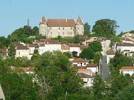
The town is overlooked by a castle that dates from the Middle Ages, and a chapel within its gardens is classified as a historic monument. While its walls date from the eleventh century, the castle was destroyed during the Hundred Years War. Today only a large gate remains of the original; the current castle was built in the 15th century in the form of a manor within the old walls. The Church of Saint-Denis, which was restored starting in the 19th century, dates from the 12th.
References
Montmoreau-Saint-Cybard Wikipedia(Text) CC BY-SA