
Country United States County Jasper FIPS code 13-52416 Elevation 207 m Zip code 31064 Local time Saturday 1:08 AM | Time zone Eastern (EST) (UTC-5) GNIS feature ID 0328830 Area 7.8 km² Population 2,613 (2013) Area code Area codes 706 and 762 | |
 | ||
Weather 14°C, Wind SW at 8 km/h, 53% Humidity | ||
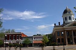
Monticello is the largest city and the county seat of Jasper County, Georgia, United States. The city includes historic buildings such as the Jasper County Courthouse, Monticello High School and the Monticello Historic District. The population was 2,428 at the 2000 census. It is 61 miles south of Atlanta.
Contents
- Map of Monticello GA 31064 USA
- History
- Geography
- Demographics
- Jasper County School District
- Notable natives and residents
- Representation in other media
- Climate
- Geology and Soils
- References
Map of Monticello, GA 31064, USA
History
Monticello was founded in 1808 as seat of the newly formed Jasper County. It was incorporated as a town in 1810 and as a city in 1901.
On January 14, 1915, about 100 white men of Monticello formed a lynch mob and lynched a black family of four, including two married women. They took Dan Barber, his son Jesse Barber, and two married daughters Bula and Ella (Barber) Charles from the county jail, where they had been put after being arrested for attacking the chief of police. He had challenged Dan Barber in his house for making liquor illegally. The mob shot and hanged each of the four.
Geography
Monticello is located at 33°18′12″N 83°41′9″W (33.303247, -83.685766).
According to the United States Census Bureau, the city has a total area of 3.0 square miles (7.8 km2), of which, 3.0 square miles (7.8 km2) of it is land and 0.04 square miles (0.10 km2) of it (0.66%) is water.
Demographics
As of the census of 2000, there were 2,428 people, 927 households, and 609 families residing in the city. The population density was 805.8 people per square mile (311.4/km²). There were 1,006 housing units at an average density of 333.9 per square mile (129.0/km²). The racial makeup of the city was 44.77% White, 53.50% African American, 0.12% Native American, 0.37% Asian, 0.70% from other races, and 0.54% from two or more races. Hispanic or Latino of any race were 3.17% of the population.
There were 927 households out of which 33.9% had children under the age of 18 living with them, 40.0% were married couples living together, 22.0% had a female householder with no husband present, and 34.3% were non-families. 31.1% of all households were made up of individuals and 14.7% had someone living alone who was 65 years of age or older. The average household size was 2.56 and the average family size was 3.21.
In the city, the population was spread out with 28.3% under the age of 18, 8.2% from 18 to 24, 26.0% from 25 to 44, 21.6% from 45 to 64, and 15.9% who were 65 years of age or older. The median age was 36 years. For every 100 females there were 79.7 males. For every 100 females age 18 and over, there were 73.1 males.
The median income for a household in the city was $35,058, and the median income for a family was $46,705. Males had a median income of $30,565 versus $21,793 for females. The per capita income for the city was $15,743. About 16.9% of families and 21.4% of the population were below the poverty line, including 24.6% of those under age 18 and 20.2% of those age 65 or over.
Jasper County School District
The Jasper County School District holds pre-school to grade twelve, and consists of two elementary schools (K-2 & 3-5 respectively), a middle school, and a high school. The district has 132 full-time teachers and over 2,181 students.
Piedmont Academy - K3-12, co-ed, member of Georgia Independent School Association, established 1970
Notable natives and residents
Representation in other media
Climate
Climate is characterized by relatively high temperatures and evenly distributed precipitation throughout the year. The Köppen Climate Classification subtype for this climate is "Cfa" (Humid Subtropical Climate).
Geology and Soils
The bedrock under Monticello is an intermediate-to-mafic type on which dark red clay with dark reddish brown loam topsoil is mapped as Lloyd series.