
Country United States FIPS code 26-55100 Elevation 194 m Population 2,360 (2013) Area code 231 | State Michigan Time zone EST (UTC-5) GNIS feature ID 1620880 Zip code 49437 Local time Friday 5:34 PM | |
 | ||
Weather 1°C, Wind SE at 13 km/h, 99% Humidity Area 8.469 km² (6.63 km² Land / 184 ha Water) | ||
Montague is a city in Muskegon County in the U.S. state of Michigan. The population was 2,361 at the 2010 census. The city is located within Montague Township, but is politically independent.
Contents
- Map of Montague MI USA
- History and culture
- Geography
- Major highways
- 2010 census
- 2000 census
- Schools
- Notable people
- Climate
- References
Map of Montague, MI, USA
The Montague ZIP code 49437 also serves all of Montague Township and White River Township, as well as a small portions of Whitehall Township and Blue Lake Township in Muskegon County and parts of Claybanks Township and Grant Township in Oceana County.
History and culture
Noah Ferry, who named the city in honor of his father, William Montague Ferry, founded the city. William Ferry founded the cities of Grand Haven and Ferrysburg in neighboring Ottawa County. Ferry Church, built in 1874, is named in honor of Noah Ferry, who died fighting for the Union at the Battle of Gettysburg in 1863.
At one time, Ferry Street, also named for the founder, was the main street through town. It was named for him because the city's post office operated on that street following its establishment in 1867, and Ferry was instrumental in getting a post office in the city. Although city hall, the city’s new post office (constructed in 2005), and a handful of businesses still operate on Ferry, Dowling Street has become the city's main route because of its eventual connection to neighboring communities and U.S. Highway 31.
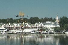
Montague is home to the "World's Largest Working Weathervane" which was constructed in part by local manufacturer Whitehall Metal Studios. The weathervane is topped by the Ella Ellenwood, a lumbering Schooner that frequented White Lake transporting lumber from Montague to Milwaukee, Wisconsin. The ship became infamous after it sank in a storm in 1901, and the wooden nameplate of the schooner floated back to the shores of the City of Montague, where it was found in 1902. Many people believed that the boat was coming home, and as a result the ship is frequently associated with the city.
Geography
According to the United States Census Bureau, the city has a total area of 3.27 square miles (8.47 km2), of which 2.56 square miles (6.63 km2) is land and 0.71 square miles (1.84 km2) is water.
The city is at the southern end of the Hart-Montague Trail, a paved cycling and multiuse trail which attracts visitors during the warm months to Montague, Hart, and the small towns and businesses in between.
Major highways
Bus. US 31 is a business loop through the downtowns of both Montague and Whitehall.
2010 census
As of the census of 2010, there were 2,361 people, 1,006 households, and 643 families residing in the city. The population density was 922.3 inhabitants per square mile (356.1/km2). There were 1,182 housing units at an average density of 461.7 per square mile (178.3/km2). The racial makeup of the city was 96.0% White, 0.6% African American, 1.0% Native American, 0.3% Asian, 0.4% from other races, and 1.6% from two or more races. Hispanic or Latino of any race were 3.4% of the population.
There were 1,006 households of which 31.9% had children under the age of 18 living with them, 46.9% were married couples living together, 13.1% had a female householder with no husband present, 3.9% had a male householder with no wife present, and 36.1% were non-families. 30.8% of all households were made up of individuals and 14.5% had someone living alone who was 65 years of age or older. The average household size was 2.35 and the average family size was 2.93.
The median age in the city was 39.9 years. 25.2% of residents were under the age of 18; 7.4% were between the ages of 18 and 24; 23.2% were from 25 to 44; 28.1% were from 45 to 64; and 16.1% were 65 years of age or older. The gender makeup of the city was 46.0% male and 54.0% female.
2000 census
As of the census of 2000, there are 2,407 people, 990 households, and 667 families residing in the city. The population density is 905.1 per square mile (349.4/km²). There are 1,075 housing units at an average density of 404.3 per square mile (156.0/km²). The racial makeup of the city is 97.17% White, 0.37% African American, 0.46% Native American, 0.25% Asian, 0.00% Pacific Islander, 0.58% from other races, and 1.16% from two or more races. 2.33% of the population are Hispanic or Latino of any race.
There are 990 households out of which 32.1% have children under the age of 18 living with them, 51.5% are married couples living together, 12.5% have a female householder with no husband present, and 32.6% are non-families. 28.3% of all households are made up of individuals and 11.7% have someone living alone who is 65 years of age or older. The average household size is 2.43 and the average family size is 2.97.
In the city, the population is spread out with 26.1% under the age of 18, 8.8% from 18 to 24, 27.0% from 25 to 44, 23.7% from 45 to 64, and 14.4% who are 65 years of age or older. The median age is 37 years. For every 100 females there are 89.8 males. For every 100 females age 18 and over, there are 87.2 males.
The median income for a household in the city is $40,677, and the median income for a family is $49,185. Males have a median income of $37,389 versus $25,282 for females. The per capita income for the city is $21,238. 9.5% of the population and 6.6% of families are below the poverty line. Out of the total population, 9.1% of those under the age of 18 and 9.3% of those 65 and older are living below the poverty line.
Schools
Montague Area Public Schools (MAPS) is the local school district for the city of Montague. Three of the district's five schools are located in the city, Montague High School, Nellie B. Chisholm (NBC) Middle School and R.R. Oehrli (RRO) Elementary School. The district's other two schools, Oceana High School and Rothbury Elementary are located in the Village of Rothbury. The district serves students of both Muskegon and Oceana counties. This arrangement exists after voters living in the district of Rothbury Public Schools agreed to merge with the district of Montague Public Schools. This merger of the two districts took place in the 1950s to increase efficiency and decrease costs for both communities, led to the formation of "Montague Area Public Schools".
The district serves students living in the Muskegon County communities of the city of Montague, as well as Montague and White River townships. In addition it serves students living in parts of Whitehall and Blue Lake townships. The district also serves students living in the Oceana County communities of the Village of Rothbury and Otto Township. It also serves students living in parts of New Era. Also, the district is a member of the "Muskegon County School of Choice" program; the district can serve anyone living in Muskegon County. The district has increased enrollment slightly from the program, but has limited growth in the past because the rural district has limited capacity for new enrollees.
The city of Montague is also the home of Saint James Catholic School. The small parochial school serves grades K-5 and has roughly 100 students. It serves students living in the Montague Area Public School District, as well as the Whitehall District Schools. The school shares busing with both districts, and dropped the sixth grade a few years after adding kindergarten. Recently, White Lake Baptist Academy (grades K-12) and Mouth School (grades K-8) closed because of dwindling enrollment.
Notable people
Climate
This climatic region is typified by large seasonal temperature differences, with warm to hot (and often humid) summers and cold (sometimes severely cold) winters. According to the Köppen Climate Classification system, Montague has a humid continental climate, abbreviated "Dfb" on climate maps.