
Prominence 372 m (1,220 ft) First ascent 6 August 1882 Mountain range Alps, Pennine Alps | Elevation 3,585 m Parent range Pennine Alps | |
 | ||
Location Valais, Switzerland/Aosta Valley, Italy Similar Bouquetins, Tête de Valpelline, L'Evêque, Punta Kurz, Mont Collon | ||
Mont brul
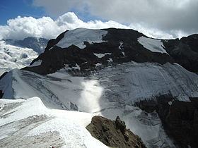
Mont Brulé (also known as Mont Brûlé or Mont Braoulé) is a mountain of the Pennine Alps, located on the Swiss-Italian border, east of the Col Collon. On its northern side it overlooks the upper Arolla Glacier.
Contents
Map of Mont Brul%C3%A9, 11010 Bionaz, Aosta Valley, Italy
Mont brul braoul
Toponym
Though in French this name means "burnt mountain", this toponym comes from Valdôtain Francoprovençal patois. According to Aostan botanist and scientist Joseph-Marie Henry, the word Broillà means "made of breuils", Breuil meaning alpine marshy berm, as for Breuil in Valtournenche.
References
Mont Brulé Wikipedia(Text) CC BY-SA