
Population 4,954 (2011 census) Area 160 ha Federal division Division of Chisholm | Postcode(s) 3127 Postal code 3127 | |
 | ||
LGA(s) City of BoroondaraCity of Whitehorse | ||
Mont Albert is a suburb of Melbourne, Victoria, Australia, 12 km east of Melbourne's Central Business District. Its local government area are the Cities of Boroondara and Whitehorse. At the 2011 Census, Mont Albert had a population of 4,954.
Contents
Map of Mont Albert VIC 3127, Australia
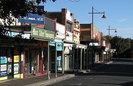
The main shopping centre of Mont Albert is Hamilton Street, a small street lined with shops. The suburb has its own railway station.
History
Mont Albert Post Office opened on 1 August 1914. A Mont Albert North Post Office opened in 1957 and closed in 1993.
Education
Churches
References
Mont Albert, Victoria Wikipedia(Text) CC BY-SA