
Location Halifax, Massachusetts Basin countries United States Max. depth 13 ft (4.0 m) Mean depth 2.13 m | Primary outflows Stump Brook Average depth 7 ft (2.1 m) Area 114 ha | |
 | ||
Surface area Western: 282 acres (1.14 km)
Eastern: 246 acres (1.00 km) | ||
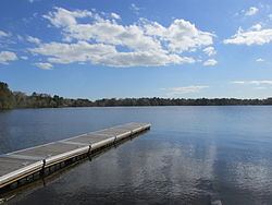
Monponsett Pond, also called Monponsett Lake and the Twin Lakes, is actually a system of two ponds, West and East, mostly in Halifax, Massachusetts, with a small portion of West Monponsett Pond extending into Hanson. The western basin is 282 acres (1.14 km2), and the eastern basin is 246 acres (1.00 km2). The average depth of both ponds is seven feet and the maximum depth is 13 feet (4.0 m). The outflow is Stump Brook, a tributary of Poor Meadow Brook, in the northwestern part of West Monponsett Pond. The pond is part of the Taunton River Watershed. Occasionally during water shortages water from this pond is diverted into Silver Lake, the principal water supply for the City of Brockton.
Map of Monponsett Pond, Halifax, MA 02338, USA
Route 58 bisects the two ponds. A paved boat launching ramp to West Monponsett Pond is on this highway north of White Island Road. A culvert connecting the two ponds is nearby. Route 106 runs close to the southern shore of East Monponsett Pond, and Route 36 abuts the southeast corner of East Monponsett Pond, where there is a paved launching ramp. Access to West Monponsett Pond is an unpaved ramp off Lingan Street. Monponsett Pond Seaplane Base is located on this pond.