
 | ||
Similar Wasatch Range, Lick Wash, Quail Creek State Park, Navajo Mountain, Grand Staircase‑Escalante National | ||
Mollie's Nipple or Molly's Nipple is the name given to as many as seven peaks, at least one butte, at least one well, and some other geological features in Utah. Some sources claim there are eleven geological features in Utah that bear this name. At least some of those names are attributed to John Kitchen – a pioneer of an early exploration of Utah, who named them to commemorate a nipple of his wife (or his bride according to some sources) Molly.
Contents
- Map of Mollies Nipple Utah 84651 USA
- Utah Mollies Nipples peaks listed by US Geological Survey
- Kane County
- Bear River Gorge
- Hurricane Valley
- References
Map of Mollies Nipple, Utah 84651, USA
Utah Mollie's Nipples peaks listed by US Geological Survey
Note: the U.S. Board on Geographic Names discourages the use of the apostrophe in place names. This has not prevented some individuals and organizations from re-inserting apostrophes dropped from possessive place names on their own.
Kane County
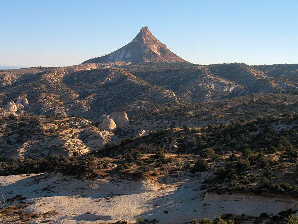
Mollies Nipple, a mountain summit at the head of Kitchen Canyon in Grand Staircase-Escalante National Monument, Kane County, is the second highest feature so named, reaching 7,264 feet (2,214.07 meters) above sea level. The climb has areas of a few classes including Class 2 and Class 3 and a short "50 foot Class 4 Pitch". The trail-head can be approached only by a four-wheel drive.
This peak is "standing alone in a land of mesas", and is easily seen from a distance between "cliffs and canyons".
Nearby at Nipple Lake, John Kitchen built his ranch, which still exists.
The story of Molly and her husband John was used to create an imaginary scenario of causes of Molly's death to teach students dating techniques.
Bear River Gorge
Molly’s Nipple rocky knob at Bear River Gorge is notable because an outlaw known by multiple names including "Black Jack Nelson" used to hide his stolen treasures at that place.
Hurricane Valley
Mollie's Nipple butte is located in Hurricane Valley Heritage Park. Its elevation is 1353 feet "above the fertile Hurricane Valley". Mollie's Nipple butte was well known to pioneers during frontier exploration of the area. The butte has an archeological significance because indigenous peoples of the Americas used the caves below the Nipple for cooking. Climbers also find some old pottery atop of the Nipple. It is believed that the butte was used "to send up smoke signals to hunting and seed gathering parties."
The butte can be climbed; those who reach the top are rewarded by "a vast circle of breath-taking, colorful, geologic and historic wonders, unmatched by any view in the world!"