
- location Rivière-Mouchalagane Length 410 km Basin area 19,200 km² Mouth Gulf of Saint Lawrence Mouth elevation 0 | - location Sept-Îles Discharge 490 m³/s Province Québec Country Canada | |
 | ||
- average 490 m/s (17,300 cu ft/s) | ||
The Moisie River is a river in eastern Quebec. Known as the Nahanni of the East, it is a wild river of North America. It flows south from Lake Opocopa near the Labrador border to the north shore of the Saint Lawrence River east of Sept-Îles, Quebec. The town of Moisie is located at its mouth. The river is 410 km in length and drains an area of 19,200 km2. The length calculated from most commonly used starting point of canoe trips, bridge of highway 389 over Pékans River (at 52°43′48.19″N 67°24′47.31″W ) is 373 km.
Map of Rivi%C3%A8re Moisie, Sept-Iles, QC, Canada
The river's name may originate from a French word moisie meaning "rotten" . But this is not certain and other hypotheses exist.
The Mishta-shipiunnu („Innu from the Moisie River“) call it Mishta-shipu ("Great River"; mishau - ″big, great″ and shipu - ″river“). As they have done for thousands of years, they continue to use the river to reach their northern hunting and fishing grounds. Large parts of the river were also protected by private fishing clubs. There were recent attempts to develop hydroelectric projects on the Moisie. However, in 2003, the Quebec government protected a large part of the river's watershed as an aquatic reserve. This prevents activities such as logging, mining and power projects, but permits traditional uses such as hunting and fly-fishing.
This river is the most important spawning ground for the Atlantic Salmon in eastern North America.
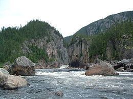
The Moisie River is popular with experienced canoeists concerning its whitewater. It flows through a deep valley of glacial origin. The width of the valley varies considerably. The views of mountains and cliffs cause it to be used for canoe camping. The Quebec North Shore & Labrador Railway follows the lower section of the Moisie River and provides access to the Quebec-Labrador plateau from which canoeists can reach its headwaters.
Moisie tributaries include: