
OS grid reference SK315155 Sovereign state United Kingdom | Local time Wednesday 6:06 PM | |
 | ||
Weather 14°C, Wind SW at 10 km/h, 53% Humidity Points of interest The National Forest, Moira Furnace, Sarah's Wood | ||
Moira is a former mining village about 2.5 miles (4 km) southwest of Ashby-de-la-Zouch in North West Leicestershire, England. The village is about 3 miles (5 km) miles south of Swadlincote and forms part of the boundary with Derbyshire. The population is included in the civil parish of Ashby Woulds.
Contents
Map of Moira, Swadlincote, UK
For centuries North West Leicestershire has been quarried and mined for coal, limestone, granite and brick clay, and its environmental damage was one of the reasons that it was chosen as the site for the National Forest, which is part of a Government-funded programme to create more woodland. Proximate villages include Donisthorpe, Overseal, Oakthorpe, Spring Cottage and Norris Hill.
Etymology
Moira's toponym is derived from the Irish earldom of Moira, one of the titles of the Hastings family, which held Ashby de la Zouch Castle. The former local colliery, Rawdon Colliery, also bore a Hastings family name. Moira is one of the few place names in England to end in an "a".
History
The Midland Railway opened its Leicester to Burton upon Trent Line through Moira in 1845. Moira railway station served the village until British Railways closed it in 1964. The building still survives and the line remains open as a freight route.
Rawdon Colliery was worked for about 150 years. Its seams extended 6 miles (10 km) from the shaft,and some had been worked twice, recovering lower grade coal. The pit survived Britain's pit closure programme in the mid-1980s that followed the miners' strike, but ran out of viable coal seams. Gases were rarely a hazard, but spontaneous combustion of coal dust was a potential problem.
Amenities
The 120 acres (49 ha) National Forest Millennium Discovery Centre, now called 'Conkers', is on the site of Rawdon Colliery. Its visitor centre features a borehole-based heating and cooling system. Moira Junction Local Nature Reserve occupies 8.5 acres (3.4 ha) of former railway sidings nearby.
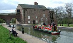
Moira Furnace is a restored 19th century blast furnace. A 1.5 miles (2.4 km) section of the Ashby Canal adjacent to the furnace has also been restored and refilled, although it lacks a navigable link to the rest of the system due to the A42 road having been built across its line. The furnace site also includes craft workshops and a small nature reserve.
Both the Youth Hostels Association's National Forest youth hostel and the Camping and Caravanning Club's National Forest campsite are in Moira and opened in 2008.
The Hicks Lodge nature reserve lies approximately 1 mile east of the village.