
- elevation 449 ft (137 m) Basin area 466.2 km² | Length 48 km Basin area 466.2 km² | |
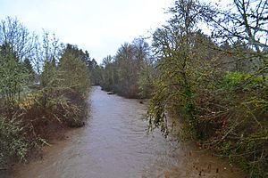 | ||
The Mohawk River is the largest tributary of the McKenzie River, approximately 30 miles (48 km) long, in west central Oregon in the United States. It drains part of the foothills of the Cascade Range on the southeast end of the Willamette Valley northeast of Springfield.
Map of Mohawk River, Oregon, USA
It rises in northern Lane County, approximately 12 miles (19 km) northeast of Springfield. It flows generally southwest and enters the McKenzie from the north on the north side of Springfield. The river's valley is known as the Mohawk Valley.
The Mohawk River was probably given its name by Jacob C. Spores in 1849. Spores was a native of the Mohawk River region of New York, and the Oregon river's valley reminded him of the Mohawk Valley in his home state. In turn, the Oregon river gave its name to the Mohawk River band of Kalapuyan Native Americans who inhabited the river valley in the 19th century. They are not related to the Mohawk tribe in the eastern United States.
Current and former settlements in the Mohawk Valley include Donna, Mabel, Marcola, Mohawk, and Wendling.
Named tributaries from source to mouth are North Fork Mohawk River and South Fork Mohawk River followed by Log, Bette, Drury, Shotgun, Polly, Mill, and Cartwright creeks. Further downstream come Parsons and McGowan creeks, then Alder Branch followed by Spores, Stafford, and Sister creeks.