
Existed: 1988 – present Counties: Hennepin Constructed 1988 | East end: MN 55 at Fort Snelling Length 19.88 km | |
 | ||
West end: I-494 / CR 62 at Eden Prairie County Hennepin County, Minnesota Major cities Minneapolis, Edina, Minnetonka, Eden Prairie, Richfield | ||
Minnesota State Highway 62 (MN 62) is a highway in the Twin Cities region of Minnesota. The route was part of Hennepin County Road 62 until 1988, when a portion of the route was inherited by the state. The western terminus of the route is at Interstate Highway 494 in Eden Prairie, where the roadway continues west as Hennepin County Road 62 to Hennepin County Road 101. The eastern terminus of the route is at State Highway 55 near the Minneapolis-Saint Paul International Airport in Minneapolis. Locally, the route is known as "the Crosstown," though signage with this name does not appear on the highway itself, but only on local streets adjacent to the road. It is also used as an alternate name, even by the Minnesota Department of Transportation.[1] Though it does follow the 62nd Street plane for most of its route, that name is less frequently used. Highway 62 is 12 miles (19 km) in length.
Contents
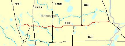
- Map of MN 62 Minnesota USA
- Route description
- History
- I 35W and Highway 62 Crosstown Commons reconstruction project
- Exit list
- References
Map of MN-62, Minnesota, USA
Route description
State Highway 62 serves as an east–west route between Eden Prairie, Minnetonka, Edina, Richfield, Minneapolis, and Fort Snelling. The route is constructed to freeway standards for most of its length, except for the western 1/2 mile, which is an expressway with two signal-controlled intersections. The route is located in Hennepin County.
Due to the existence of a second State Highway 62 in the southwest corner of the state between Fulda and Windom, the stretch of Highway 62 in the Twin Cities area starts its numbering at milepost 100. This is unorthodox in that the two state highways have a combined length of 36 miles (58 km). "Mile 100" is calibrated where Hennepin County Roads 101 and 62 meet at the Eden Prairie / Minnetonka boundary line; though the mileposts themselves, starting with mile 104, do not appear until the state-maintained section inside the I-494 beltway.
History
State Highway 62 in the Twin Cities area was authorized in 1988. Prior to 1988, the route was designated as Hennepin County Road 62. The route was built mostly in the late 1960s by Hennepin County.
The original Hennepin County numbering of 62 corresponded with 62nd Street in Minneapolis. However, some portions of Highway 62 do stray from the 62nd Street plane, as near the eastern terminus, Highway 62 runs along the plane of 58th Street.
Highway 62 previously had a traffic light at its eastern terminus at Highway 55 until an interchange was reconstructed during construction of the METRO Blue Line light rail in 2004.
I-35W and Highway 62 Crosstown Commons reconstruction project
The Twin Cities' Highway 62 had one of the most notorious junctions in the region where it interwove with Interstate Highway 35W. This mile-long stretch was known informally as the "Crosstown Commons". Plans to "unweave" and expand this section of roadway to improve traffic flow had come and gone for many years, frustrating the 200,000 drivers who used it daily. Construction of the current design was expected to begin in July 2006, but was delayed due to state budget deficits.
The project was adequately funded during Governor Tim Pawlenty's second term and bids were received in April 2007. The bid was won by the Ames, Lunda, and Schafer consortium for $288 million. Construction began in May 2007. The project included 25 new bridges, 63 lane-miles of highway, and expanded the total roadway width from 6 lanes to 12 lanes at Lyndale Avenue. The bridges were cast in Coates, Minnesota and trucked in for on-site erection. The new design includes transit / HOV lanes and was completed in November 2010. The new interchange features three through-lanes for I-35W (including one HOV lane) in each direction and two separate through-lanes for Highway 62 in each direction, eliminating the need to weave across traffic. The 2007 cost of correcting the deficiencies in that short stretch of highway was estimated to be $285 million.
Exit list
The entire route is in Hennepin County. All exits are unnumbered.