
Primary inflows Basin countries United States Area 61 ha Inflow source Agawam River | Primary outflows Agawam River Surface area 150 acres (61 ha) Outflow location Agawam River | |
 | ||
Similar | ||
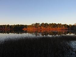
Mill Pond, also known unofficially as Agawam Mill Pond, is a 150-acre (0.61 km2) pond in Wareham, Massachusetts. The pond is located northwest of Union Pond, west and north of Spectacle Pond, west of Sandy Pond, and southwest of Glen Charlie Pond. The Agawam River runs through the pond. Route 25 runs through the southwestern part of the pond, and the Exit 2 off-ramp from Route 25 eastbound lies along the shore en route to Glen Charlie Road, which runs along the pond's eastern shore.
Map of Mill Pond, Wareham, MA, USA
References
Mill Pond (Wareham, Massachusetts) Wikipedia(Text) CC BY-SA