
Prominence 32 m OS grid SK061904 | Listing TuMP Elevation 544 m | |
 | ||
Topo map OS Landranger 110; OL1W | ||
Mill Hill is an open, flat-topped hill, 544 metres (1,785 ft) high, in the Peak District in the county of Derbyshire in England.
Contents
Location
Mill Hill lies about 4 kilometres (2.5 mi) southeast of the town of Glossop in the hills of Derbyshire's Peak District and a similar distance northwest of the Peak's highest point at Kinder Scout.
Description
Mill Hill is a bare, domed summit covered by peat moorland that lies on the route of the Pennine Way about 4 kilometres (2.5 mi) northwest of the highest point in the Peak District, Kinder Scout. There is a cairn and marker pole at the summit. The summit area has been eroded by visitors such that the highest point is now to the NE.
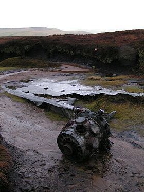
Aircraft crash site
On 11 October 1944, a Liberator of the US 310th Ferry Squadron, 27th Air Transport Group, crashed at Mill Hill. The aircraft was being moved from RAF Burtonwood to RAF Hardwick. After having problems at take-off, the aircraft climbed to 2,800 feet. After experiencing turbulence, the aircraft flew into the ground in low cloud despite a warning from the navigator. The 2 crewmen, 2nd Lt Creighton R Houpt and SSgt Jerome M Najvar, survived the crash.