
Location Omaha, Nebraska NRHP Reference # 93001400 Added to NRHP 10 December 1993 | Architect Capt. Edward Beckwith Year built 1858 | |
 | ||
Military Road is a central thoroughfare located in Omaha, Nebraska. A segment of the road located at the junction of West 82nd and Fort Streets was listed on the National Register of Historic Places in 1993. Today Military Road, which begins at Nebraska Highway 64 as Nebraska Highway L-28K, ends at Bennington Road near North 204th Street (Nebraska Highway 31).
Contents
Map of Military Rd, Nebraska, USA
History
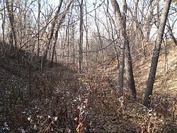
Originally part of the Overland Trail, Military Road was laid out from Downtown Omaha westward through the town of Benson and past in 1857 by Captain Edward Beckwith for the U.S. Army. Originally designated as a shipment road for moving military supplies to Fort Kearny, thousands of travelers moving to the Pacific Northwest used the road for the next fifty years. Purposely laid out over high ground, emigrants and freighters had a clear view of the surrounding country as a protection against attacks.
Currently
The original graded wagon track can be seen near the Omaha Public Power District substation located near West 90th Street. A section of the road is listed on the National Register of Historic Places.