
Country United States County Hillsborough Time zone Eastern (UTC-5) Elevation 79 m Population 15,115 (2010) | Incorporated 1794 Area code(s) 603 Zip code 03055 Local time Wednesday 8:06 AM | |
 | ||
Weather 1°C, Wind NW at 27 km/h, 56% Humidity | ||
Milford is a town in Hillsborough County, New Hampshire, United States, on the Souhegan River. The population was 15,115 at the 2010 census. It is the retail and manufacturing center of a six-town area known informally as the Souhegan Valley.
Contents
Map of Milford, NH 03055, USA
The town center of Milford, where 8,835 people resided at the 2010 census, is defined as the Milford census-designated place (CDP), and is located at the junction of New Hampshire routes 13 and 101A.
History
Milford separated from neighboring Amherst in 1794. Like most towns named Milford in the United States, its name comes from the fact that it grew around a mill built on a ford—in this case on the Souhegan River.
Milford was once home to numerous granite quarries, which produced a stone that was used, among other things, to make the pillars for the U.S. Treasury in Washington, D.C.—pillars that can be seen on the back of the American $10 bill, although it is unclear whether that will remain after the bill is redesigned. Its nickname remains "The Granite Town," although only one small quarry is in operation as of 2017.
Like many New England riverside towns, Milford developed several thriving textile mills in the 19th century. That industry left New England by World War II, but Milford remains the commercial and retail center for surrounding towns. Major employers included casting company Hitchiner Manufacturing Co., a metal cable manufacturer Hendrix Wire and Cable Inc. and a contract manufacturing solutions company, Cirtronics Corporation.
Milford is home to the Milford State Fish Hatchery. The town also holds the Souhegan Valley Boys & Girls Club, built on the former home of the now-bankrupt private theater American Stage Festival.
Milford was a stop on the Underground Railroad for escaped slaves. It was also the home of Harriet E. Wilson, who published the semi-autobiographical novel Our Nig: Or, Sketches in the Life of a Free Black in 1859, making it the first novel by an African-American published in the country.
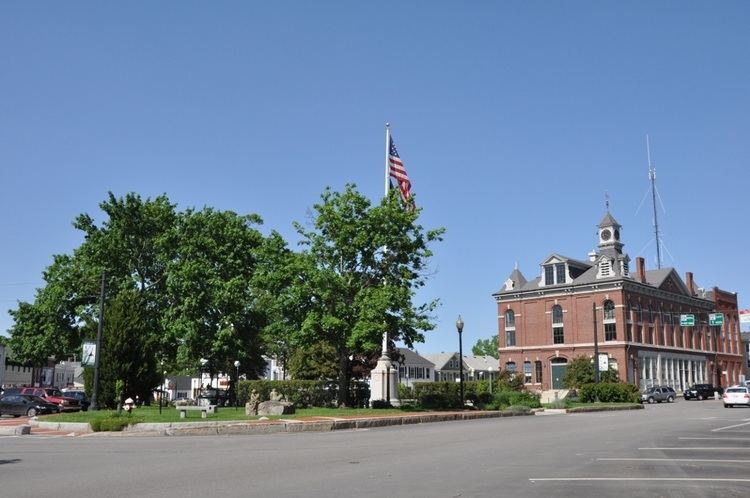
Officially designated Union Square, the Milford Oval is neither square nor oval in shape, but rather triangular. The "square" name in American parlance denotes a town common irrespective of geometry, and the "oval" name dates from the 19th century, when it was oval in shape. The Oval is the town center, with the Pillsbury Bandstand as its centerpiece and the Souhegan River as backdrop. The Oval is formed by a modified traffic rotary in which State Highways 13 and 101A intersect, with northbound 13 and eastbound 101A passing straight through and crossing each other at a right angle with a stop sign for traffic on Route 13. For many years, the Oval's traffic flow was treated as a series of three individual intersections of three one-way streets, resulting in the unusual arrangement whereby vehicles entering the Oval had right-of-way over vehicles turning left to continue through the Oval. This treatment was reversed in the 1980s to conform with traffic rotary norms whereby vehicles already in the Oval have right-of-way over vehicles entering the Oval.
Geography
According to the United States Census Bureau, the town has a total area of 25.3 square miles (66 km2), of which 25.2 sq mi (65 km2) is land and 0.1 sq mi (0.26 km2) is water, comprising 0.24% of the town. Milford is drained by the Souhegan River. The town's highest point is near its western border, on the summit of Boynton Hill, at 814 feet (248 m) above sea level.
The town center, or census-designated place, has a total area of 5.7 square miles (15 km2), of which 0.04 sq mi (0.10 km2), or 0.52%, is water.
Milford is bordered by Lyndeborough and Mont Vernon to the north, Amherst to the east, Hollis to the southeast, Brookline to the south, Mason to the southwest, and Wilton to the west.
Demographics
As of the census of 2000, there were 13,575 people, 5,201 households, and 3,547 families residing in the town. The population density was 536.5 people per square mile (207.1/km²). There were 5,316 housing units at an average density of 210.7 per square mile (81.4/km²). The racial makeup of the town was 96.76% White, 0.90% Black or African American, 0.14% Native American, 0.92% Asian, 0.01% Pacific Islander, 0.21% from other races, and 1.06% from two or more races. Hispanic or Latino of any race were 1.17% of the population.
There were 5,201 households out of which 37.3% had children under the age of 18 living with them, 54.8% were married couples living together, 9.8% had a female householder with no husband present, and 31.8% were non-families. 25.1% of all households were made up of individuals and 7.8% had someone living alone who was 65 years of age or older. The average household size was 2.58 and the average family size was 3.11.
In the town, the population was spread out with 27.7% under the age of 18, 6.6% from 18 to 24, 34.5% from 25 to 44, 21.5% from 45 to 64, and 9.6% who were 65 years of age or older. The median age was 35 years. For every 100 females there were 96.4 males. For every 100 females age 18 and over, there were 92.0 males.
The median income for a household in the town was $52,343, and the median income for a family was $61,682. Males had a median income of $42,244 versus $28,220 for females. The per capita income for the town was $24,425. About 3.1% of families and 5.2% of the population were below the poverty line, including 6.0% of those under age 18 and 8.0% of those age 65 or over.
Town center
As of the census of 2000, there were 8,293 people, 3,379 households, and 2,098 families residing in the town center, or census-designated place (CDP). The population density was 1,450.3 people per square mile (559.8/km²). There were 3,463 housing units at an average density of 605.6 per square mile (233.8/km²). The racial makeup of the CDP was 96.49% White, 0.99% Black or African American, 0.10% Native American, 1.01% Asian, 0.01% Pacific Islander, 0.14% from other races, and 1.25% from two or more races. Hispanic or Latino of any race were 1.06% of the population.
There were 3,379 households out of which 33.7% had children under the age of 18 living with them, 47.9% were married couples living together, 10.4% had a female householder with no husband present, and 37.9% were non-families. 30.3% of all households were made up of individuals and 9.9% had someone living alone who was 65 years of age or older. The average household size was 2.42 and the average family size was 3.05.
In the CDP, the population was spread out with 26.0% under the age of 18, 7.4% from 18 to 24, 34.2% from 25 to 44, 20.8% from 45 to 64, and 11.5% who were 65 years of age or older. The median age was 35 years. For every 100 females there were 93.6 males. For every 100 females age 18 and over, there were 89.2 males.
The median income for a household in the CDP was $48,716, and the median income for a family was $57,933. Males had a median income of $40,412 versus $27,126 for females. The per capita income for the CDP was $24,025. About 3.3% of families and 5.2% of the population were below the poverty line, including 4.3% of those under age 18 and 9.8% of those age 65 or over.
Culture
The town is known for its "Pumpkin Festival" which is normally held in early October. It is held over a three-day weekend (Friday-Sunday) and attracts more than 35,000 people. The festival has many attractions including food vendors, music stages, craft fair, carved pumpkin lighting, a haunted trail, a beer and wine tasting and a fireworks display around the Oval.