
Time zone IST (UTC+5:30) Elevation 326 m | PIN 64130X | |
 | ||
Weather 31°C, Wind E at 6 km/h, 47% Humidity University Forest College and Research Institute Points of interest Black Thunder, Nilgiri Mountain Railway, Subramaniar Temple | ||
Mettupalayam is a taluk of Coimbatore Rural district, located to the north of the city of Coimbatore on the way to Ooty. It is located in the foot hills of Nilgiri hills about 38 km north of downtown Coimbatore, in the Indian state of Tamil Nadu. Mettupalayam is the third largest township in the district and one of the fast developing suburbs on the northern side of Coimbatore. As of 2011, the town had a population of 66,595.
Contents
Map of Mettupalayam, Tamil Nadu
Geography
Mettupalayam is located at 11.3000°N 76.9500°E / 11.3000; 76.9500. It has an average elevation of 314 metres (1033 feet). Mettupalayam is situated on the bank of Bhavani River at the foot of the Nilgiri mountains.
Demographics
According to 2011 census, Mettupalayam had a population of 69,213 with a sex-ratio of 1,022 females for every 1,000 males, much above the national average of 929. A total of 6,808 were under the age of six, constituting 3,543 males and 3,265 females. Scheduled Castes and Scheduled Tribes accounted for 14.76% and .08% of the population respectively. The average literacy of the town was 77.11%, compared to the national average of 72.99%. The town had a total of 18423 households. There were a total of 26,595 workers, comprising 147 cultivators, 437 main agricultural labourers, 704 in house hold industries, 23,870 other workers, 1,437 marginal workers, 8 marginal cultivators, 60 marginal agricultural labourers, 92 marginal workers in household industries and 1,277 other marginal workers.
As per the religious census of 2011, Mettupalayam had 69.24% Hindus, 25.65% Muslims, 4.84% Christians, 0.02% Sikhs, 0.15% Jains, 0.04% following other religions and 0.05% following no religion or did not indicate any religious preference.
Politics
Mettupalayam (State Assembly Constituency) is part of Nilgiris (Lok Sabha constituency).
Transport
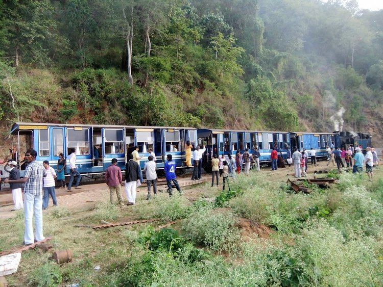
The Nilgiri Mountain Railway which connects Mettupalayam railway station with Udagamandalam (Ooty) is a UNESCO world heritage site. Nilgiri Express connects Mettupalayam to capital Chennai via Coimbatore. Mettupalayam is situated at the base of Nilgiri Hills and hence is the starting point for the Ghat Roads. Coimbatore is 38 km by road from Mettupalayam and the nearest airport is Coimbatore International Airport.
Places of interest
The Kotagiri road is a walking spot where one can see spotted deer and elephants. Major temples include Vana Bathrakali Amman temple, Idugampalayam Aanjineyar temple, Then Tirupathi, Kurunthamalai and Kumaran Kundru Murugan temples and Karamadai Ranganadar temple. Black Thunder is a theme park in Mettupalayam.