
Time zone NZST (UTC+12) | Elevation 20 m | |
 | ||
Mercer is a village in the Waikato District Council area of the Waikato region of the North Island of New Zealand. It is 70 km north of Hamilton and 58 km south of Auckland, on the east bank of the Waikato River, 2 km south of its confluence with the Mangatawhiri River.
Contents
Map of Mercer, New Zealand
Mercer has a primary school and its shops and cafes continue to fill the role of a midpoint refreshment stop between Hamilton and Auckland, which its railway station refreshment room once did.
History
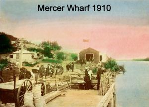
The first attack in the invasion of the Waikato took place on 17 July 1863, when about 15 Māori defenders were killed at Koheroa (a kilometre north - see 1:50,000 map). The village was named after a Captain killed at Rangiriri in November 1863. The navy river gun-boat Pioneer was wrecked on the Manukau bar in 1866 and one of the gun turrets forms part of the war memorial.
The North Island Main Trunk railway opened to Mercer on 20 May 1875. A crash in 1940 killed the driver and fireman. Until 1958 many trains stopped for refreshments. The station closed in 1986.
The beached hulls of steamers operated until 1976 by Caesar Roose can be seen on the west bank of the river just south of Mercer. In 1965 Caesar offered $100,000 towards the $343,000 bridge to replace the Mercer ferry. The 480 feet long single span concrete Caesar Roose Bridge was opened on 18 November 1972.