
Elevation 8,147 ft (2,483 m) | Passes Mentasta Pass | |
 | ||
Peak Noyes Mountain (Alaska) Length 40 mi (64 km) East-West Width 25 mi (40 km) North-South Similar Mount Sanford, Mount Kimball, Mount Wrangell, Mount Drum, Mount Blackburn | ||
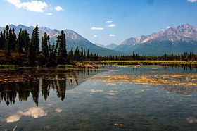
The Mentasta Mountains in the eastern part of the U.S. state of Alaska form the eastern end of the Alaska Range. They lie south of the Alaska Highway, east of the Glenn Highway, north of the Wrangell Mountains, and west of the Nabesna River. Across the Glenn Highway lies the continuation of the Alaska Range, while across the Nabesna River lie the Nutzotin Mountains. They form the northern boundary of Wrangell-St. Elias National Park & Preserve. The highest point of the Mentasta Mountains is Noyes Mountain with an elevation of 8,147 feet (2,483 m).
Map of Mentasta Mountains, Alaska 99586, USA
References
Mentasta Mountains Wikipedia(Text) CC BY-SA