
Country United States FIPS code 48-47460 Elevation 392 m Zip code 76370 Population 194 (2013) | Time zone Central (CST) (UTC-6) GNIS feature ID 1362579 Area 160 ha Local time Friday 6:51 PM Area code 940 | |
 | ||
Weather 30°C, Wind SE at 11 km/h, 39% Humidity | ||
Megargel (/ˈmiːɡɑːrɡəl/ MEE-gar-gəl) is a town in Archer County, Texas, United States. It is part of the Wichita Falls, Texas Metropolitan Statistical Area. The population was 203 at the 2010 census. The town is named for Roy C. Megargel, the president of the railroad that developed the town.
Contents
- Map of Megargel TX 76370 USA
- History
- Geography
- Demographics
- Education
- Government and infrastructure
- Economy
- Media
- References
Map of Megargel, TX 76370, USA
History
Megargel was established as a result of the Gulf, Texas and Western Railroad extending services to Jacksboro and Seymour. The town was established in 1910. The community developed multiple businesses within three months because the purchasers of land who established businesses sixty days after acquiring their lots received discounts as an incentive to do so.
There were 350 residents in 1914. In 1923 the population increased to 475. Around that time H. Sheets drilled a new oil well in the Swastika oilfield, causing a population increase. Oil was discovered 4 miles (6.4 km) east of Megargel in 1925, and the town expanded even more. One year later the town had 1,000 residents, and in 1927 it increased by 200 more people. 1,200 people lived in Megargel in 1927, but the population began a decline after that point. The railroad stopped operations in 1943. The number of residents was 347 by 1950, 244 in 1990, 248 in 2000, and 203 in 2010.
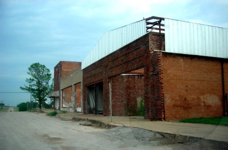
In 2014 there were 130 active water meters out of the 200 in Megargel, and many houses were unoccupied. That year Bill Hanna of the Fort Worth Star-Telegram stated that downtown Megargel was "virtually empty, littered with crumbling and abandoned buildings and outdated gas stations." Hanna stated that some Megargel residents believed that the demise of the Megargel Independent School District was a factor in recent population declines.
Geography
Megargel is located at 33°27′14″N 98°55′39″W (33.453883, -98.927546).
According to the United States Census Bureau, the town has a total area of 0.6 square miles (1.6 km2), all of it land.
The town is 110 miles (180 km) northwest of Fort Worth.
Demographics
As of the census of 2000, there were 248 people, 104 households, and 66 families residing in the town. The population density was 404.4 people per square mile (157.0/km²). There were 132 housing units at an average density of 215.3 per square mile (83.6/km²). The racial makeup of the town was 93.55% White, 0.81% African American, 0.40% Native American, 1.21% Asian, and 4.03% from two or more races. Hispanic or Latino of any race were 6.05% of the population.
There were 104 households out of which 29.8% had children under the age of 18 living with them, 51.0% were married couples living together, 7.7% had a female householder with no husband present, and 35.6% were non-families. 31.7% of all households were made up of individuals and 8.7% had someone living alone who was 65 years of age or older. The average household size was 2.38 and the average family size was 2.97.
In the town, the population was spread out with 24.2% under the age of 18, 5.6% from 18 to 24, 29.0% from 25 to 44, 26.6% from 45 to 64, and 14.5% who were 65 years of age or older. The median age was 41 years. For every 100 females there were 100.0 males. For every 100 females age 18 and over, there were 116.1 males.
The median income for a household in the town was $30,000, and the median income for a family was $36,250. Males had a median income of $26,429 versus $23,750 for females. The per capita income for the town was $14,783. About 4.2% of families and 4.3% of the population were below the poverty line, including 1.8% of those under the age of eighteen and none of those sixty five or over.
Education
Megargel is served by the Olney Independent School District.
Megargel was served by the Megargel Independent School District. By 2006 the school (along with the town) has been declining for years, and is currently running out of funds. The school board has voted to consolidate with Olney ISD, the neighboring school district in Olney, Texas (about 12 miles southeast), subject to voter approval on May 13, 2006. Proponents argued that the school (which had only 63 students, including only one in seventh grade) simply cannot continue to function, and consolidation with the neighboring district (which had nearly 800 students) would provide more opportunities for educational achievement. Opponents feared that closure of the school would cause the town to disappear. The vote was in favor of consolidation. The school and district closed after the school year ended.
Government and infrastructure
The community post office had opened within three months of Megargel's establishment. The United States Postal Service continues to operate the Megargel Post Office.
Economy
Megargel had a hotel, a bank, and 23 stores within three months of its founding. By 1986 Megargel had nine businesses.
Media
The community previously had a newspaper, Megargel Times, established by 1914.