
Local authority North Orakei (1.6 km) | Population 11,016 (2006) | |
 | ||
Train station(s) Meadowbank Railway Station Southeast Saint Johns, New Zealand (1.9 km) Northeast Mission Bay, New Zealand (2.0 km) | ||
Meadowbank is a suburb of Auckland city, in the North Island of New Zealand.
Map of Meadowbank, Auckland 1072, New Zealand
Meadowbank is under the local governance of the Auckland Council. The 2006 census counted the suburb as two parts, Meadowbank North and South, with St John's Road as the dividing line. The two areas combined have a population of 11,016.
Meadowbank has two shopping centres: Meadowbank Shopping Centre, on the corner of Gerard Way and St John's Road, and The Junction, formerly a tram station, on the corner of Meadowbank Road and St John's Road.
Purewa Cemetery, one of central Auckland's largest cemeteries, is situated in Meadowbank and can be accessed from St John's Road. St John's College and Trinity Theological College are also located on St John's Road.
Local primary schools are Meadowbank School (public) and Mt Carmel School, Meadowbank (state-integrated Catholic). Local secondary schools are Selwyn College and Baradene College of the Sacred Heart.
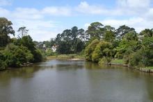
Meadowbank is also home to the Waiatarua Reserve, the biggest urban wetland restoration project in New Zealand. The 20-hectare reserve was once a freshwater lake, but the landscape was altered by the Maungarei / Mount Wellington volcanic eruptions approximately 9000 years ago.