
Traversed by OR 242 | Elevation 1,626 m | |
 | ||
Similar | ||
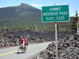
McKenzie Pass (elev. 5335 ft/1623 m) is a mountain pass in the Cascade Range in central Oregon, United States.
Map of McKenzie Pass, Oregon 97413, USA
It is located at the border of Linn and Deschutes counties, approximately 20 mi (32 km) northwest of Bend, between the Three Sisters to the south and Mt. Washington to the north. Oregon Route 242 passes over the pass.
At the summit of the pass, Oregon Route 242 crosses a 65-square-mile (170 km2) lava flow just west of Sisters. Surrounded by lava, the Dee Wright Observatory was constructed in 1935 by Civilian Conservation Corps workers and named after their foreman. Visitors climb to the observatory to view the Cascade peaks visible from McKenzie Pass. Also near the summit is Clear Lake, a renowned location for fresh-water diving.
Highway 242 is not recommended for large trucks, trailers or motor homes due to numerous tight switchbacks. The pass is closed from November to July due to snow.