
Country United States County Wabaunsee FIPS code 20-43775 Elevation 310 m Population 253 (2013) Area code 785 | Time zone Central (CST) (UTC-6) GNIS feature ID 0476608 Zip code 66501 Local time Thursday 11:34 AM | |
 | ||
Weather 13°C, Wind S at 24 km/h, 51% Humidity Area 49 ha (47 ha Land / 3 ha Water) | ||
McFarland is a city in Wabaunsee County, Kansas, United States. As of the 2010 census, the city population was 256.
Contents
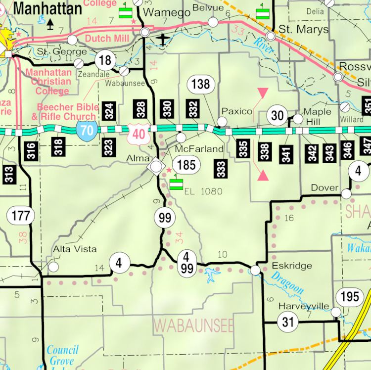
Map of McFarland, KS, USA
History
McFarland was established in June 1887 by S.H. Fairfield. It was named after J. N. McFarland, a Topeka, Kansas judge and member of the town company.
In 1887, the Chicago, Kansas and Nebraska Railway built a main line from Topeka through McFarland to Herington. The Chicago, Kansas and Nebraska Railway was foreclosed in 1891 and taken over by Chicago, Rock Island and Pacific Railway, which shut down in 1980 and reorganized as Oklahoma, Kansas and Texas Railroad, merged in 1988 with Missouri Pacific Railroad, merged in 1997 with Union Pacific Railroad. Most locals still refer to this railroad as the "Rock Island".
Circa 1910, over 30 passenger trains per day passed through McFarland.
Geography
McFarland is located at 39°3′12″N 96°14′20″W (39.053241, -96.238934). According to the United States Census Bureau, the city has a total area of 0.19 square miles (0.49 km2), of which, 0.18 square miles (0.47 km2) is land and 0.01 square miles (0.03 km2) is water.
Climate
The climate in this area is characterized by hot, humid summers and generally mild to cool winters. According to the Köppen Climate Classification system, McFarland has a humid subtropical climate, abbreviated "Cfa" on climate maps.
Demographics
McFarland is part of the Topeka, Kansas Metropolitan Statistical Area.
2010 census
As of the census of 2010, there were 256 people, 110 households, and 68 families residing in the city. The population density was 1,422.2 inhabitants per square mile (549.1/km2). There were 123 housing units at an average density of 683.3 per square mile (263.8/km2). The racial makeup of the city was 95.7% White, 0.4% Native American, 0.8% from other races, and 3.1% from two or more races. Hispanic or Latino of any race were 4.7% of the population.
There were 110 households of which 30.0% had children under the age of 18 living with them, 48.2% were married couples living together, 9.1% had a female householder with no husband present, 4.5% had a male householder with no wife present, and 38.2% were non-families. 31.8% of all households were made up of individuals and 12.7% had someone living alone who was 65 years of age or older. The average household size was 2.33 and the average family size was 3.00.
The median age in the city was 40.5 years. 21.9% of residents were under the age of 18; 8.6% were between the ages of 18 and 24; 24.3% were from 25 to 44; 30.5% were from 45 to 64; and 14.8% were 65 years of age or older. The gender makeup of the city was 54.3% male and 45.7% female.
2000 census
As of the census of 2000, there were 271 people, 105 households, and 72 families residing in the city. The population density was 1,525.6 people per square mile (581.3/km²). There were 115 housing units at an average density of 647.4 per square mile (246.7/km²). The racial makeup of the city was 98.15% White, 0.37% African American, and 1.48% from two or more races. Hispanic or Latino of any race were 1.11% of the population.
There were 105 households out of which 35.2% had children under the age of 18 living with them, 54.3% were married couples living together, 7.6% had a female householder with no husband present, and 30.5% were non-families. 22.9% of all households were made up of individuals and 6.7% had someone living alone who was 65 years of age or older. The average household size was 2.58 and the average family size was 3.05.
In the city, the population was spread out with 31.0% under the age of 18, 5.9% from 18 to 24, 30.3% from 25 to 44, 20.7% from 45 to 64, and 12.2% who were 65 years of age or older. The median age was 36 years. For every 100 females there were 105.3 males. For every 100 females age 18 and over, there were 98.9 males.
The median income for a household in the city was $32,250, and the median income for a family was $45,250. Males had a median income of $31,250 versus $23,173 for females. The per capita income for the city was $15,419. About 7.1% of families and 11.1% of the population were below the poverty line, including 9.9% of those under the age of eighteen and 11.5% of those sixty five or over.