
Country Canada Settled c. 1800s Population 97 (2011) | Census division 3 Postal Code A0N 2J0 Local time Thursday 10:00 AM | |
 | ||
Area code(s) 709 & 846-XXXX where x is the other numbers Weather 1°C, Wind SW at 35 km/h, 84% Humidity | ||
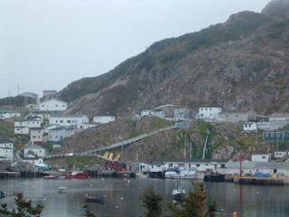
McCallum is an isolated community on the southern coast of Newfoundland. It is accessible only by boat or by air, and in appearance and way of life is thought by some to be as close to a pre-20th century community as may be found. McCallum lies in an enclosed harbour and is sheltered between two hills. The community survives primarily on the fishery. Whaling was also a major industry in the late 19th century. It is also about an hour and a half from the nearest road, in a similar community called Hermitage.
Contents
Map of McCallum, NL, Canada
Geography
As a result of resettlement, the community has grown and has taken in people from surrounding communities such as Pushthrough, Muddy Hole, Indian Cove, Lock's Cove, Richards Harbour, Great Jervais and Mosquito.
In the past there was only a muddy or dirt walkway. Today there is a wooden walkway and also two major concrete roads. Walking is still the primary means of land transport around the community. ATVs have become rather popular, however.
History
McCallum takes its name from Sir Henry Edward McCallum, Colonial Governor of Newfoundland and Labrador from 1899 to 1901.
The waters around McCallum have been fished since at least the 16th century, however no permanent settlement existed until after the Seven Years' War, after 1816. When the French gained possession of the Islands of Saint Pierre and Miquelon, the English on the Islands were forced to find new homes, and looked just north, to Newfoundland's southern coast.
It was during this time that Captain James Cook was appointed marine surveyor of Newfoundland, and mapped out in detail the coastline and waters around McCallum to create a boundary for where the French were still allowed to fish.
Facilities
McCallum has a public wharf, a fire department, a bed-and-breakfast, local internet access, a ferry service to Hermitage (where the nearest road is located), and distance education facilities. There is only one general store, Fudges Store (there were two for many years until Riggs and Sons Ltd. went out of business); the church is St Peter's Anglican, and the school is St Peter's All Grade School. The school is small with only around ten students. Distance education is a popular means of education for the high school students (grades 9 to 12), through Desire2Learn which is called D2L for short and CDLI. CDLI uses D2L as the content management system, D2L alone does not do anything.
There are now more than four ATV's used for various jobs in the community, such as garbage pickup, hauling freight, and bringing groceries to the shop. Also, ATVs have become popular for residents needing to get various jobs done quicker. Snowmobiles are popular in winter.
Aside from the traditional fishery, there is also a lobster fishery.
In recent years there has also been aquaculture in and around the community of McCallum. However, it is now little seen. The lifeblood of McCallum revolves around the sea.
McCallum is quickly decreasing in population, and because of its size there are limits on what establishments can do.
McCallum like many other rural towns has its own slang, and local folklore.