
Population 715 (2011 census) Postal code 2145 | Postcode(s) 2145 | |
 | ||
Lga City of Parramatta Council | ||
Mays Hill is a suburb of Sydney, in the state of New South Wales, Australia. Mays Hill is located 24 kilometres west of the Sydney central business district, in the local government areas of the Cumberland Council and City of Parramatta, and is part of the Greater Western Sydney region.
Contents
Map of Mays Hill NSW 2145, Australia
Mays Hill has a stop on the T-80 T-Way bus service. It is also served by several Westbus bus routes.
History
Originally some of the land that is now Mays Hill was part of the governor's domain. This was subdivided and Thomas May was one of the purchesers.
Demographics
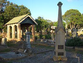
Mays Hill Cemetery
Mays Hill Cemetery is the one of four historic cemeteries in City of Parramatta local government area and contains the graves of many well known local pioneering families including the Paytens, Fullagars, Houisons, Downs, Ardills and Mustons. This cemetery was originally known as Western Road Cemetery as it is located on the Great Western Highway.