
Main source Dzhugdzhur Mountains Length 1,087 km Basin area 171,000 km² Mouth Aldan River | River mouth Aldan River Discharge 1,180 m³/s Source Dzhugdzhur Mountains Country Russia | |
 | ||
Basin size 171,000 km (66,000 sq mi) | ||
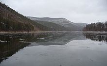
Maya River (Russian: Майя, or Мая) is a river in Khabarovsk Krai and Sakha, Russia. It is a right tributary of the Aldan River of the Lena basin. The length of the river is 1,053 kilometres (654 mi). The area of its basin 171,000 square kilometres (66,000 sq mi). The Maya River freezes up in late October and stays under the ice until May. The Yudoma River is one of the biggest tributaries of the Maya. The river is navigable up to 500 kilometres (310 mi) upstream from its mouth.
Map of Maya River, Russia
The Maya was part of the river route from Yakutsk to the Okhotsk Coast. Its course is approximately "V"-shaped. The upper Maya runs about 201 kilometres (125 mi) southwest parallel to the coast between the Dzhugdzhur Mountains and the Yudoma Plateau. About 80 kilometres (50 mi) from its source the Mati River comes in from the south. From the Mati either the Lama Portage or the Alanchak Portage led to the Ulya River and the coast. Near the southernmost point was the settlement of Nelkan from which a track led over the mountains to Ayan. The Maya flows west for perhaps 64 kilometres (40 mi) and receives the Maimakan River from the southwest. From here the river flows basically north about 320 kilometres (200 mi), receives the Yudoma River from the east and joins the Aldan River at Ust-Maya. From Ust-Maya there was a horse-track to Yakutsk. Eastbound boats that reached Ust-Maya from the Lena River were replaced by smaller boats to continue up the Maya.