
FIPS code 55-50025 Elevation 269 m Population 4,456 (2013) Area code 608 | Time zone Central (CST) (UTC-6) GNIS feature ID 1569135 Zip code 53948 Local time Wednesday 12:55 PM | |
 | ||
Weather -2°C, Wind W at 16 km/h, 37% Humidity Area 12.41 km² (11.37 km² Land / 104 ha Water) | ||
Mauston is a city in and the county seat of Juneau County, Wisconsin, United States. The population is 4,411 according to the 2010 census. It is approximately seventy miles northwest from the state capital, Madison.
Contents
Map of Mauston, WI 53948, USA
History
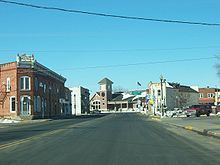
Mauston was founded by Milton M. Maughs. The town was originally named Maughs Town after Maughs. The town's beginning was based on the lumber industry of early Wisconsin. The history of Mauston is currently preserved in the Boorman House on Union Street.
Geography
Mauston is located at 43°48′N 90°5′W (43.798, -90.077). It is in the Central Standard time zone. Elevation is 883 feet.
According to the United States Census Bureau, the city has a total area of 4.79 square miles (12.41 km2), of which, 4.39 square miles (11.37 km2) is land and 0.40 square miles (1.04 km2) is water.
Airport
Mauston is serviced by the Mauston-New Lisbon Union Airport (82C). The airport is joint owned with New Lisbon.
2010 census
As of the census of 2010, there were 4,423 people, 1,779 households, and 985 families residing in the city. The population density was 1,007.5 inhabitants per square mile (389.0/km2). There were 2,006 housing units at an average density of 456.9 per square mile (176.4/km2). The racial makeup of the city was 92.8% White, 2.6% African American, 1.2% Native American, 0.7% Asian, 0.7% from other races, and 2.0% from two or more races. Hispanic or Latino of any race were 3.5% of the population.
There were 1,779 households of which 29.3% had children under the age of 18 living with them, 35.9% were married couples living together, 13.7% had a female householder with no husband present, 5.8% had a male householder with no wife present, and 44.6% were non-families. 37.3% of all households were made up of individuals and 17.4% had someone living alone who was 65 years of age or older. The average household size was 2.25 and the average family size was 2.94.
The median age in the city was 39.3 years. 22.3% of residents were under the age of 18; 8.7% were between the ages of 18 and 24; 26.6% were from 25 to 44; 25.4% were from 45 to 64; and 17.1% were 65 years of age or older. The gender makeup of the city was 50.1% male and 49.9% female.
2000 census
As of the census of 2000, there were 3,740 people, 1,585 households, and 963 families residing in the city. The population density was 1,022.6 people per square mile (394.5/km²). There were 1,729 housing units at an average density of 472.8 per square mile (182.4/km²). The racial makeup of the city was 96.28% White, 0.67% African American, 0.35% Native American, 1.18% Asian, 0.48% from other races, and 1.04% from two or more races. Hispanic or Latino of any race were 2.11% of the population.
There were 1,585 households out of which 29.1% had children under the age of 18 living with them, 45.0% were married couples living together, 11.8% had a female householder with no husband present, and 39.2% were non-families. 33.5% of all households were made up of individuals and 18.7% had someone living alone who was 65 years of age or older. The average household size was 2.28 and the average family size was 2.89.
In the city, the population was spread out with 24.2% under the age of 18, 8.6% from 18 to 24, 27.1% from 25 to 44, 19.2% from 45 to 64, and 20.9% who were 65 years of age or older. The median age was 38 years. For every 100 females there were 88.1 males. For every 100 females age 18 and over, there were 81.4 males.
The median income for a household in the city was $32,341, and the median income for a family was $42,866. Males had a median income of $31,250 versus $21,589 for females. The per capita income for the city was $21,640. About 8.7% of families and 11.9% of the population were below the poverty line, including 18.4% of those under age 18 and 15.4% of those age 65 or over.
Education
The city and surrounding area is served by the Mauston Area School District, which provides a 4-year-old kindergarten through senior high education. District schools include West Side Elementary (grades 4K-2), Grayside Elementary (grades 3-5), Olson Middle School (which is housed in the former high school and serves grades 6, 7, and 8), and Mauston High School, which opened its doors in 2001. Lyndon Station Elementary School, which houses grades K-5, is located in nearby Lyndon Station.
A pre-K through 8th grade Catholic parochial school has been operated by St. Patrick Parish since 1895. The parish also operated St. Patrick High School from 1933–1951, and Madonna High School from 1951-1966. This school holds about 200 students from all counties of Southern Wisconsin.
Mauston is also home to a campus of Western Technical College.