
Lowest elevation 0 m (0 ft) Postal code 190 09 Area 10 km² | Highest elevation 10 m (30 ft) Time zone EET (UTC+2) Area code(s) 2294 0 Local time Wednesday 8:32 AM | |
 | ||
Weather 12°C, Wind NE at 3 km/h, 73% Humidity | ||
Mati (Greek: Mάτι meaning eye) is a village in Greece. This holiday resort is on the east coast of the Attica region, 29 kilometres (18 mi) east of Athens.
Contents
Map of Mati, Nea Makri 190 05, Greece
Overview
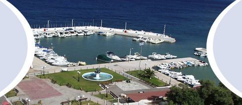
Mati is a popular tourist destination harboring several hotels, fish restaurants, tavernas, cafés, bars, night clubs, open air cinemas, sandy beaches, yacht marinas and hotels. The harbour in nearby Rafina serves as an access point to the Aegean Sea and is frequently used by tourists to reach many of Greece's numerous islands. The Penteli mountains that are covered with forests lie to the west and northwest. Beaches cover the eastern part and restaurants, hotels, and tavernas line the shore.
Geography
Rafina lies east of the Penteli mountains, on the Marathonas Avenue north of Rafina and south of Nea Makri. Mati is about 30 km (19 mi) east of downtown Athens.
Road and sea access
The town can be accessed through Marathonos Avenue (GR-54) to the west or alternatively via the Dionissos mountains Northwest of Athens.
Mati is closely located to the port of Rafina, which serves as a local hub for holiday ferry boats to the Cyclades islands.