
Local time Tuesday 4:23 PM | ||
 | ||
Name meaning "The shrine or place of martyrdom" Weather 16°C, Wind W at 18 km/h, 58% Humidity | ||
Mashhad (Hebrew: מַשְׁהַד, Arabic: مشهد, Mash-hed transliteration, grave of a holy man) is an Arab town located 5 kilometers (3.1 mi) northeast of Nazareth in Israel's Northern District. In 2015 it had a population of 7,858, most of whom were Muslims.
Contents
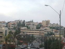
Map of Mashhad, Israel
History
Remains from the Early Bronze Age, Persian, Roman and Byzantine eras have been found.
Traces of ancient ruins have been found.
Ottoman era
In 1517, the village was incorporated into the Ottoman Empire with the rest of Palestine, and in 1596 it appeared in the Ottoman tax registers under the name of Mashad Yunis, as being in the nahiya (subdistrict) of Tabariyya under the Liwa of Safad. It had a population of 31 households and 6 bachelors, all Muslim, who paid taxes on a number of crops, including wheat and barley, fruit trees, vegetable and fruit garden, orchard, as well as on goats and/or beehives.
A map from Napoleon's invasion of 1799 by Pierre Jacotin showed the place, named as El Mecheb.
In 1875, the French explorer Victor Guérin visited the village, which he estimated had at most 300 inhabitants. In 1881, the Palestine Exploration Fund's Survey of Western Palestine (SWP) described Meshed as "A small village, built of stone, surrounding the traditional tomb of Jonah -a low building surmounted by two white- washed domes. It contains about 300 Moslems, and is situated on the top of a hill, without gardens. The water supply is from cisterns."
British Mandate era
In the 1922 census of Palestine, conducted by the British Mandate authorities, Mashad had a total population of 356, all Muslim, which had increased in the 1931 census to 487; 486 Muslims and 1 Christian, in a total of 111 houses.
In 1945 the population was 660, all Arabs, with 11,067 dunams of land, according to an official land and population survey. Of this, 378 dunams were for plantations and irrigable land, 4,663 for cereals, while 24 dunams were built-up land.
1948, and after
Mashhad became a local council in 1960.