
Province New Brunswick | ||
 | ||
Marysville is a Canadian suburban neighbourhood in the city of Fredericton, New Brunswick. Located in the northeast end of the city, Marysville is situated on the Nashwaak River 5 kilometres north of its confluence with the Saint John River. Until 1973, Marysville was a separately incorporated town and it still tries to maintain an identity distinct from the rest of the city.
Contents
Map of Marysville, Fredericton, NB, Canada
History
The village was initially an Acadian village named Sainte Marie. During the Expulsion of the Acadians, the village was burned in the St. John River Campaign (1758).
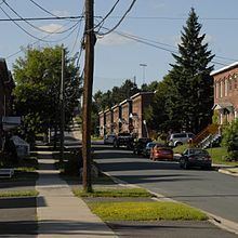
The community was re-established over a hundred years later by Alexander Gibson and was incorporated by the act of the New Brunswick Legislature. Gibson named the village after his wife and his eldest daughter, both of whom were named Mary. Gibson built up several industries in Marysville, most notably a cotton mill. A large number of brick duplexes were built around the mill, most of which are still standing. Marysville was named a National Historic Site of Canada in 1993 for being one of Canada's last intact 19th-century mill towns.
After the cotton mill closed in 1975, the building was renovated and converted into provincial government offices under the name Marysville Place. Almost all of the old brick duplexes are still in use and privately owned today.