
Area 1.32 sq mi (3.4 km) OS grid reference SJ66690275533 | Population 538 Local time Monday 7:11 PM | |
 | ||
Unitary authority Weather 9°C, Wind W at 3 km/h, 82% Humidity | ||
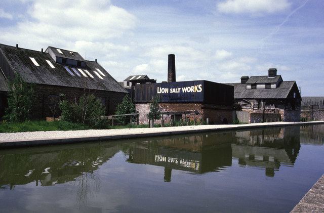
Marston is a village and civil parish in the unitary authority of Cheshire West and Chester, in the northwest of England. The settlement is on the River Weaver, close to Anderton and the Anderton Boat Lift. The nearest major settlement to Marston is Manchester, which lies 15 miles (24 km) to the northeast. It is the site of the Lion Salt Works, now an industrial museum.
Contents
Map of Marston, UK
Landscape
Marston lies west of the Peak District on the Cheshire Plain. Superficial Alluvium deposits on the West side of Marston has produced higher, fluctuating topography in this area as well as Glaciofluvial deposits on the South side producing a ridge by Wincham Brook. The surrounding flat areas are composed of Devensian Till.
History
One of Marston's defining features is its old salt mine. First worked on since around 1777, the mine covers an excavated area of 85 acres.
In 1884:
"one salt mine, the most noticeable, was visited by the Emperor Nicholas of Russia ".Since then the mine has been illuminated with over 10,000 lights, used for banquets and visited by distinguished members of the British Association in 1854. The new lighting and visit by the British Association attracted almost 1,000 individuals to the mine in one day.
In 1874 the Church of St Paul was erected. Designed by Mr. Douglas, architect of Chester, in the Early English style, it consists of an organ chamber on the south side, nave, north aisle with porch and a low spire and turret containing one bell.
Population, institutional and occupational history
Historically Marston was a Township in the Great Budworth Parish (Bucklow Hundred, SJ 6776) and became a Civil Parish in 1866. Between 1837 and 2009 Marston had been part of 5 Registration districts- Northwhich (1837–1974), Vale Royal (1974–1998), Cheshire Central (1998–2007), Cheshire (2007–2009) and Cheshire West and Chester (2009+). In 1889 Marston's area was reduced by 272 acres due to a boundary change- Wincham, East of Marston, gained this area which included 18 individuals as well as Jackson's and Barber's Farm. Marston had a population of 538 according to the 2011 census.
In 1881 the primary occupation (making up 12.4% of the total population) was "Worker in Mineral Substances". This large section of employment would have been due to Marstons extensive salt mine. At this time period workers in this industry where all male- 23% of males worked in this industry in 1881.