
Local time Sunday 7:01 PM | Overseas collectivity Saint Martin Population 5,700 (2006) | |
 | ||
Weather 26°C, Wind E at 16 km/h, 71% Humidity Points of interest Fort Louis, Baie de Marigot, Baie de la Potence | ||
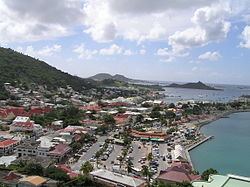
Marigot is the main town and capital in the French Collectivity of Saint Martin.
Contents
- Map of Marigot Collectivity of Saint Martin
- Population
- Geography
- Climate
- Transport
- History and features
- References
Map of Marigot, Collectivity of Saint Martin
Population
As of 2006, it has 5,700 inhabitants.
Geography
Marigot is located on the west coast of the island of St. Martin. It extends from the coast to the west, along the Bay of Marigot and the hills of the interior of the island to the east. On the south-west it is bounded by the Simpson Bay.
Climate
This area typically has a pronounced dry season. According to the Köppen Climate Classification system, Marigot has a tropical savanna climate, abbreviated "Aw" on climate maps.
Transport
The city is served by Princess Juliana International Airport as well as L'Espérance Airport. There is a ferry to Blowing Point, Anguilla.
History and features
Originally a fishing village on a swamp for which it was named, Marigot was made capital during the reign of King Louis XVI, who built Fort St. Louis on a hill near Marigot Bay. Today, that building is the most important in Marigot.
Marigot is typical of Caribbean towns, with gingerbread houses and sidewalk bistros. Market days are every Wednesday and Saturday morning. The crew of the 1998 in film motion picture Speed 2 shot the finale scene here where the Seabourn Legend hits the island.