
Elevation 400 m (1,300 ft) Local time Monday 11:43 PM Municipal unit Tylissos | City established 1394 Time zone EET (UTC+2) Postal code 71500 | |
 | ||
Weather 12°C, Wind S at 10 km/h, 86% Humidity | ||
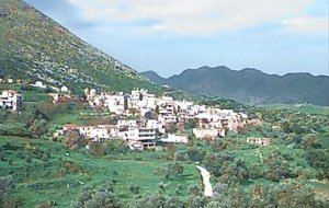
Marathos is a mountain village in the municipality of Malevizi, in the Crete region of Greece. It is about 20 kilometres west of Heraklion. The Marathianos River runs nearby and flows down to Fodele. The village relies mainly on agriculture, livestock and bee keeping.
Contents
Map of Marathos 715 00, Greece
On the main road there is a war monument commemorating the many battles on the island of Crete. It was built by the sculptor Yanni Klinakis.
The village has 5 tavernas and a traditional cafeteria.
Doxa cavern
A short distance from the village is the historical cave of Doxa. At the entrance there is a map that shows the cave layout.
Arkaliospilio cavern
At the foot of the mountain is Arkaliospilio cave. A large part of this cave is still unexplored.
References
Marathos, Crete Wikipedia(Text) CC BY-SA