
Country United States County Wabaunsee FIPS code 20-44500 Elevation 297 m Zip code 66507 Local time Monday 1:02 PM | Time zone Central (CST) (UTC-6) GNIS feature ID 0476617 Area 65 ha Population 621 (2013) Area code 785 | |
 | ||
Weather 23°C, Wind N at 23 km/h, 46% Humidity | ||
How to say or pronounce usa cities maple hill kansas
Maple Hill is a city in Wabaunsee County, Kansas, United States. As of the 2010 census, the city population was 620.
Contents
- How to say or pronounce usa cities maple hill kansas
- Map of Maple Hill KS USA
- History
- Geography
- Demographics
- 2010 census
- 2000 census
- Education
- Notable people
- References
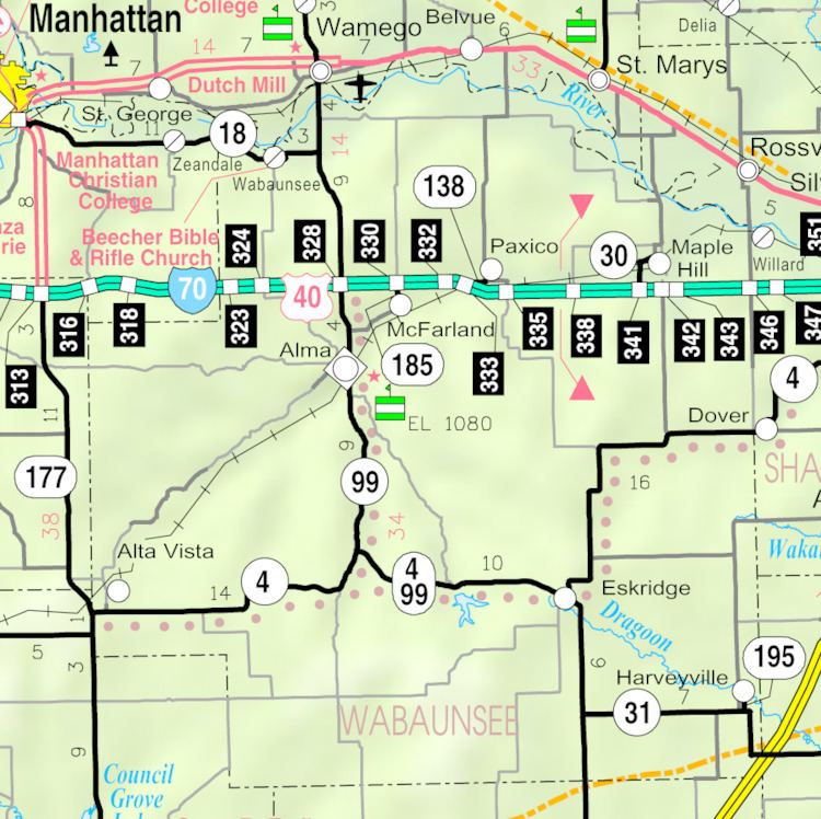
Map of Maple Hill, KS, USA
History
Maple Hill was founded about 1882. It was named from a grove of maple trees groving upon an elevation.
In 1887, the Chicago, Kansas and Nebraska Railway built a main line from Topeka through Maple Hill to Herington.
Three fires erupted in Maple Hill between 1900 and 1901.
The Chicago, Kansas and Nebraska Railway was foreclosed in 1891 and taken over by Chicago, Rock Island and Pacific Railway, which shut down in 1980 and reorganized as Oklahoma, Kansas and Texas Railroad, merged in 1988 with Missouri Pacific Railroad, merged in 1997 with Union Pacific Railroad. Most locals still refer to this railroad as the "Rock Island".
Geography
Maple Hill is located at 39°5′3″N 96°1′37″W (39.084041, -96.027071). According to the United States Census Bureau, the city has a total area of 0.25 square miles (0.65 km2), all of it land.
Demographics
Maple Hill is part of the Topeka, Kansas Metropolitan Statistical Area.
2010 census
As of the census of 2010, there were 620 people, 210 households, and 152 families residing in the city. The population density was 2,480.0 inhabitants per square mile (957.5/km2). There were 217 housing units at an average density of 868.0 per square mile (335.1/km2). The racial makeup of the city was 95.8% White, 0.2% African American, 0.3% Native American, 0.2% Asian, 0.3% from other races, and 3.2% from two or more races. Hispanic or Latino of any race were 3.9% of the population.
There were 210 households of which 43.8% had children under the age of 18 living with them, 59.5% were married couples living together, 10.0% had a female householder with no husband present, 2.9% had a male householder with no wife present, and 27.6% were non-families. 23.8% of all households were made up of individuals and 12.4% had someone living alone who was 65 years of age or older. The average household size was 2.95 and the average family size was 3.62.
The median age in the city was 30.8 years. 38.2% of residents were under the age of 18; 4.8% were between the ages of 18 and 24; 26.3% were from 25 to 44; 19.2% were from 45 to 64; and 11.6% were 65 years of age or older. The gender makeup of the city was 49.5% male and 50.5% female.
2000 census
As of the census of 2000, there were 469 people, 182 households, and 133 families residing in the city. The population density was 1,880.6 people per square mile (724.3/km²). There were 187 housing units at an average density of 749.8 per square mile (288.8/km²). The racial makeup of the city was 96.80% White, 1.49% African American, 0.21% Native American, and 1.49% from two or more races. Hispanic or Latino of any race were 1.07% of the population.
There were 182 households out of which 35.7% had children under the age of 18 living with them, 63.2% were married couples living together, 7.7% had a female householder with no husband present, and 26.4% were non-families. 24.2% of all households were made up of individuals and 11.5% had someone living alone who was 65 years of age or older. The average household size was 2.58 and the average family size was 3.04.
In the city, the population was spread out with 29.0% under the age of 18, 4.9% from 18 to 24, 31.3% from 25 to 44, 19.4% from 45 to 64, and 15.4% who were 65 years of age or older. The median age was 35 years. For every 100 females there were 95.4 males. For every 100 females age 18 and over, there were 94.7 males.
The median income for a household in the city was $46,875, and the median income for a family was $53,393. Males had a median income of $38,750 versus $26,667 for females. The per capita income for the city was $17,048. About 9.3% of families and 6.6% of the population were below the poverty line, including 6.5% of those under age 18 and 11.6% of those age 65 or over.
Education
School unification consolidated Alma, Maple Hill, McFarland and Paxico schools forming USD 329 Wabaunsee. Wabaunsee High School is located in Alma. The Wabaunsee High School mascot is Wabaunsee Chargers.
Maple Hill High School was closed through school unification.
Notable people
Among its notable historical residents was Joseph Norman Dolley, the Kansas banking commissioner who promoted the nation's first state blue sky law, which Kansas passed in 1911.